alb9527371
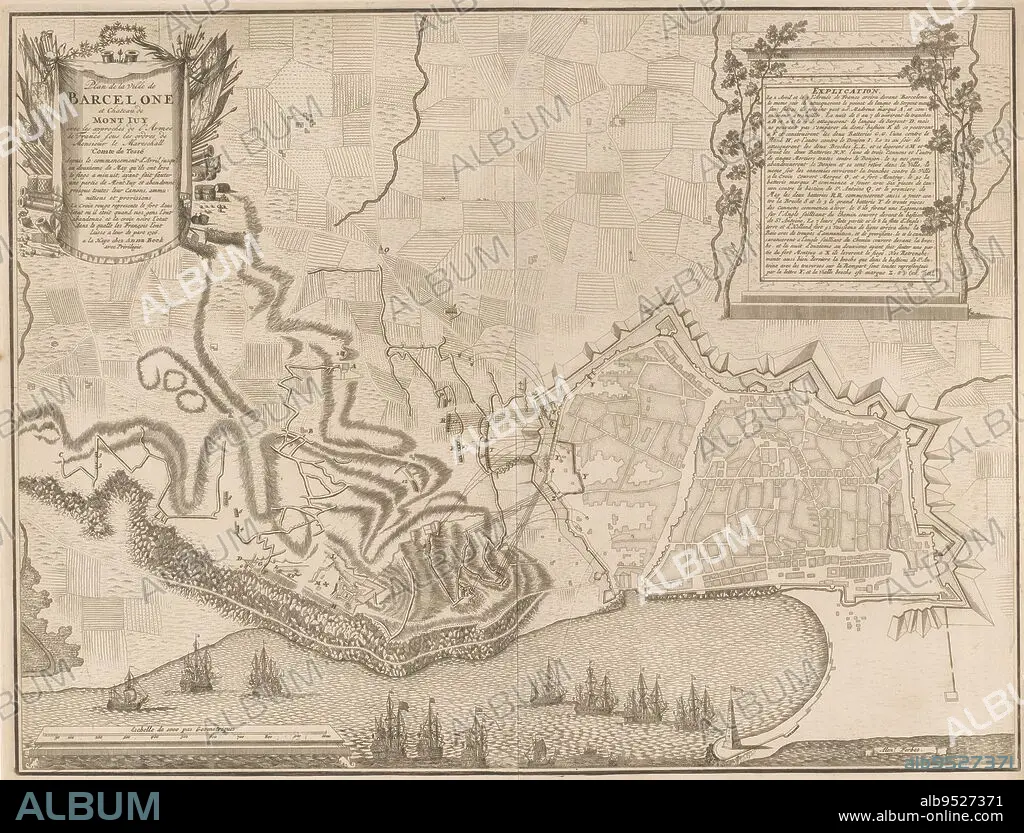
Map of the siege of Barcelona by the French and Spaniards from April onwards but relieved by the Allies on 12 May 1706, Map of the siege of Barcelona, 1706 Plan de la ville de Barcelona and Chateau de Mont Juy with the approvals (...), print maker: Jan van Call (II), (mentioned on object), intermediary draughtsman: Alexander Forbes, (mentioned on object), publisher: Anna Beeck, (mentioned on object), The Hague, 1706, paper, engraving, etching, h 455 mm × w 596 mm.
| Teilen |
|---|
 Pinterest Pinterest |
 Twitter Twitter |
 Facebook Facebook |
 Link kopieren Link kopieren |
 Email Email |
|
Zu einem anderen Lightbox hinzufügen |
|
Zu einem anderen Lightbox hinzufügen |


Haben Sie bereits ein Konto? Anmelden
Sie haben kein Konto? Registrieren
Dieses Bild kaufen.
Nutzung auswählen:

Untertitel: Siehe automatische Übersetzung
Map of the siege of Barcelona by the French and Spaniards from April onwards but relieved by the Allies on 12 May 1706, Map of the siege of Barcelona, 1706 Plan de la ville de Barcelona and Chateau de Mont Juy with the approvals (...), print maker: Jan van Call (II), (mentioned on object), intermediary draughtsman: Alexander Forbes, (mentioned on object), publisher: Anna Beeck, (mentioned on object), The Hague, 1706, paper, engraving, etching, h 455 mm × w 596 mm
Map of the siege of Barcelona by the French and Spaniards from April onwards but relieved by the Allies on 12 May 1706, Map of the siege of Barcelona, 1706 Plan de la ville de Barcelona and Chateau de Mont Juy with the approvals (...), print maker: Jan van Call (II), (mentioned on object), intermediary draughtsman: Alexander Forbes, (mentioned on object), publisher: Anna Beeck, (mentioned on object), The Hague, 1706, paper, engraving, etching, h 455 mm × w 596 mm
Persönlichkeiten: JAN VAN CALL
Bildnachweis: Album / quintlox
Freigaben (Releases): ? Modellfreigabe: Nein - ? Eigentumsfreigabe: Nein
Rechtefragen?
Rechtefragen?
Bildgröße: 5087 × 3874 px | 56.4 MB
Druckgröße: 43.1 × 32.8 cm | 2002.8 × 1525.2 in (300 dpi)
Schlüsselwörter: BARCELONA • FRANZOESISCH • FRANZOSE • FRANZÖSIN • GRAVUR • JAN VAN CALL • KARTE (KARTHOGRAFIE) • KARTEN • KARTHOGRAPHIE • LANDKARTE • OBJEKT • PAPIER • PLAN (KARTOGRAPHIE) • STICH (KUNST)
