alb15431405
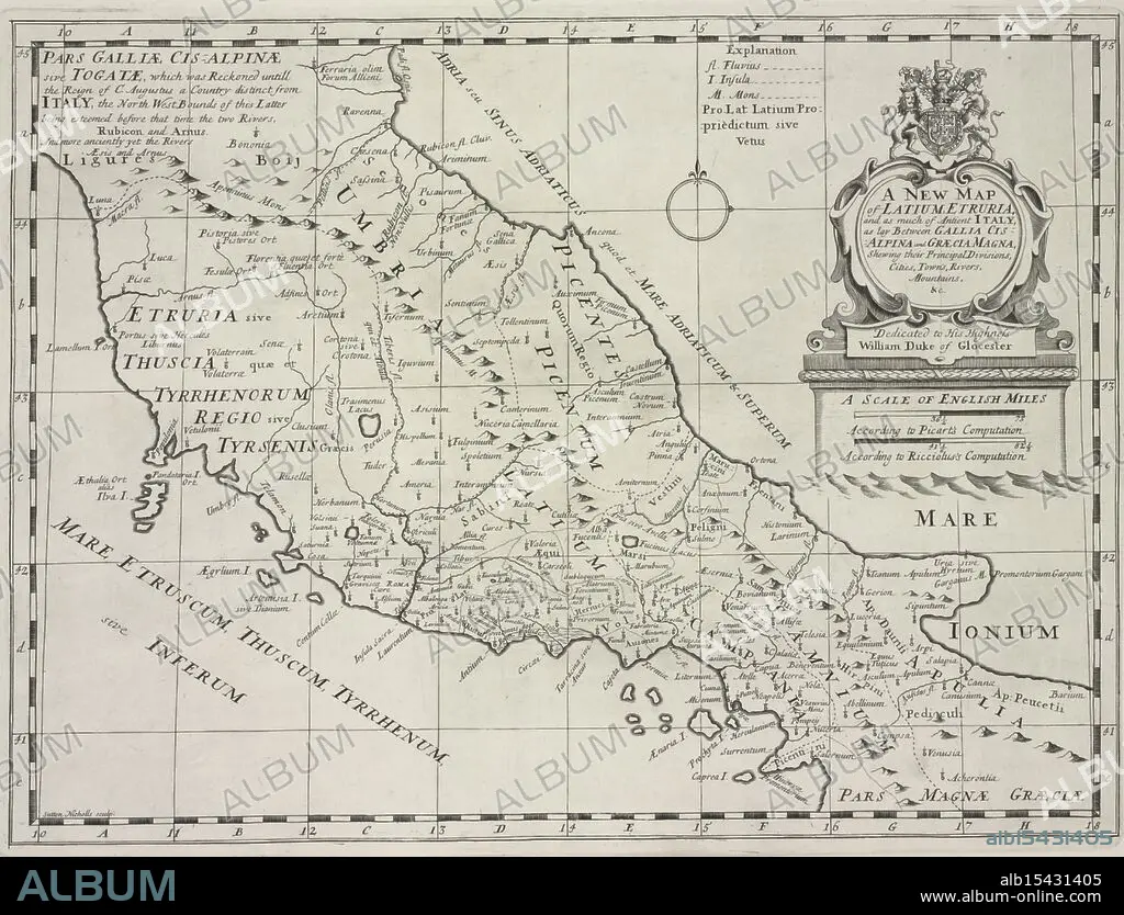
A new map of Latium, Etruria, and as much of ancient Itally, as lay between Gallia Cisalpina and Græcia Magna, shewing their principal divisions, cities, towns, rivers, mountains &c., 1700, Sheldonian Theatre, Additional title: Latium, and Etruria., Date Issued: 1700, Place: Oxford :, Publisher: Printed at theTheater, Atlases, British, Geography, Ancient, Maps in education, England, Maps, Ancient lands unfold, Cities rise amidst the hills, History's terrain.
| Teilen |
|---|
 Pinterest Pinterest |
 Twitter Twitter |
 Facebook Facebook |
 Link kopieren Link kopieren |
 Email Email |
|
Zu einem anderen Lightbox hinzufügen |
|
Zu einem anderen Lightbox hinzufügen |


Haben Sie bereits ein Konto? Anmelden
Sie haben kein Konto? Registrieren
Dieses Bild kaufen.
Nutzung auswählen:

Untertitel:
Siehe automatische Übersetzung
A new map of Latium, Etruria, and as much of ancient Itally, as lay between Gallia Cisalpina and Græcia Magna, shewing their principal divisions, cities, towns, rivers, mountains &c., 1700, Sheldonian Theatre, Additional title: Latium, and Etruria., Date Issued: 1700, Place: Oxford :, Publisher: Printed at theTheater, Atlases, British, Geography, Ancient, Maps in education, England, Maps, Ancient lands unfold, Cities rise amidst the hills, History's terrain.
Bildnachweis:
Album / quintlox
Freigaben (Releases):
Model: Nein - Eigentum: Nein
Rechtefragen?
Rechtefragen?
Bildgröße:
4794 x 3656 px | 50.1 MB
Druckgröße:
40.6 x 31.0 cm | 16.0 x 12.2 in (300 dpi)
Schlüsselwörter:
ALT (ALTER) • ALTERTÜMLICH • ANTIK • ATLANTEN • AUSBILDEN • AUSBILDUNG • BELEHRUNG • BILDUNG • ENGLAND • ERZIEHUNG • FLUSS • GEOGRAFIE • GEOGRAPHIE • GROSSBRITANNIEN • GROßBRITANNIEN • KARTE (KARTHOGRAFIE) • KARTEN • KARTHOGRAPHIE • LANDKARTE • PAEDAGOGIK • PLAN (KARTOGRAPHIE) • PÄDAGOGIK • SCHULE, ERZIEHUNG, LEHREN • SCHULWESEN • STADT • STÄDTE • UNTERRICHT
