alb5527458
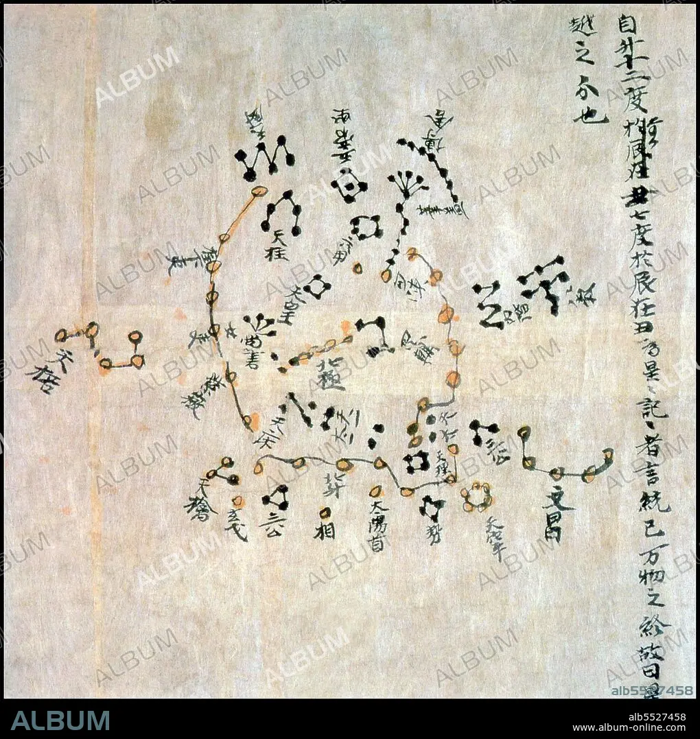
China: Section of a late Tang Dynasty star chart representing the North Polar region. Mogao Caves, Dunhuang, Gansu, c. 7th-8th century.
| Teilen |
|---|
 Pinterest Pinterest |
 Twitter Twitter |
 Facebook Facebook |
 Link kopieren Link kopieren |
 Email Email |
|
Zu einem anderen Lightbox hinzufügen |
|
Zu einem anderen Lightbox hinzufügen |


Haben Sie bereits ein Konto? Anmelden
Sie haben kein Konto? Registrieren
Dieses Bild kaufen.
Nutzung auswählen:

Titel: China: Section of a late Tang Dynasty star chart representing the North Polar region. Mogao Caves, Dunhuang, Gansu, c. 7th-8th century.
Untertitel: Siehe automatische Übersetzung
The Dunhuang map or Dunhuang Star map is one of the first known graphical representations of stars from ancient Chinese astronomy, dated to the Tang Dynasty (618–907). Before this map, much of the star information mentioned in historical Chinese texts had been questioned. The map provides a graphical verification of the star observations, and are part of a series of pictures on one of the Dunhuang manuscripts. The Dunhuang Star map is to date the world's oldest complete preserved star atlas.
The Dunhuang map or Dunhuang Star map is one of the first known graphical representations of stars from ancient Chinese astronomy, dated to the Tang Dynasty (618–907). Before this map, much of the star information mentioned in historical Chinese texts had been questioned. The map provides a graphical verification of the star observations, and are part of a series of pictures on one of the Dunhuang manuscripts. The Dunhuang Star map is to date the world's oldest complete preserved star atlas.
Bildnachweis: Album / Pictures from History/Universal Images Group
Freigaben (Releases): ? Modellfreigabe: Nein - ? Eigentumsfreigabe: Nein
Rechtefragen?
Rechtefragen?
Bildgröße: 4247 × 4263 px | 51.8 MB
Druckgröße: 36.0 × 36.1 cm | 1672.0 × 1678.3 in (300 dpi)
Schlüsselwörter: ASIEN • ASIEN, KONTINENT • CHINESIN • CHINESISCH • GESCHICHTE • GEWERBE • KARTE (KARTHOGRAFIE) • KARTEN • KARTHOGRAFIE • KARTHOGRAPHIE • KARTOGRAFIE (KARTE) • KARTOGRAPHIE • KONTINENT, ASIEN • LANDKARTE • PLAN (KARTOGRAPHIE) • REISE • REISENDER • WALZ • WISSENSCH.: KARTOGRAPHIE • ZEITGESCHICHTE
