alb5413076
Anglo-Saxon Mappa Mundi, 11th Century
| Teilen |
|---|
 Pinterest Pinterest |
 Twitter Twitter |
 Facebook Facebook |
 Link kopieren Link kopieren |
 Email Email |
|
Zu einem anderen Lightbox hinzufügen |
|
Zu einem anderen Lightbox hinzufügen |


Haben Sie bereits ein Konto? Anmelden
Sie haben kein Konto? Registrieren
Dieses Bild kaufen

Titel:
Anglo-Saxon Mappa Mundi, 11th Century
Untertitel:
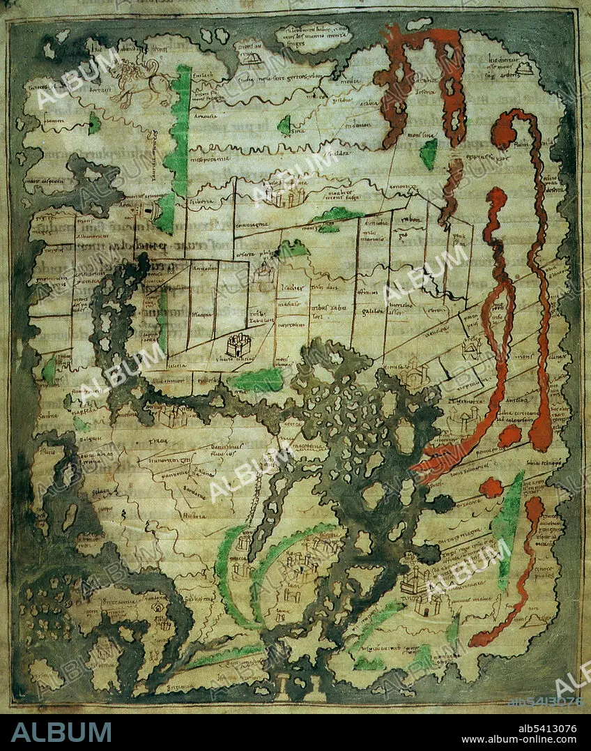
Automatische Übersetzung: Im Vergleich zu vielen anderen Ländern verfügt England über eine verhältnismäßig große Fülle an frühem kartografischem Material. Diese Karte wurde wahrscheinlich zwischen 1025 und 1050 in Canterbury erstellt, basiert aber wahrscheinlich auf einem Modell aus der Römerzeit. Sie enthält die früheste bekannte, relativ realistische Darstellung der Britischen Inseln, die in der unteren linken Ecke dieser Karte zu sehen ist. Wie bei den meisten frühen Karten ist auch hier Osten oben, dennoch sind die Britischen Inseln sofort erkennbar, ebenso wie die umliegenden Inseln (die Orkneyinseln, Scilly-Inseln, Kanalinseln und die Inseln Man und Wight). Die Halbinsel Cornwall ist übertrieben dargestellt, aber am interessantesten sind vielleicht die beiden kämpfenden Figuren, die den Konflikt zwischen den Sachsen und den einheimischen Briten in den Jahrhunderten nach dem Abzug der Römer darstellen könnten.
Compared with many lands, England has a comparative wealth of early cartographic material. This map was probably created at Canterbury between 1025 and 1050, but is probably ultimately based on a model dating from Roman times. It contains the earliest known, relatively realistic depiction of the British Isles, seen in the bottom left hand corner of this map. Like most early maps, this one has East at the top, nevertheless the British Isles is immediately recognizable, as are the surrounding islands (the Orkneys, Scillies, Channel Islands and the Isles of Man and Wight). The Cornish peninsula is exaggerated, but perhaps most interesting are the two fighting figures which may represent the conflict between the Saxons and the native Britons in the centuries following the departure of the Romans.
Persönlichkeiten:
Bildnachweis:
Album / Science Source
Freigaben (Releases):
Model: Nein - Eigentum: Nein
Rechtefragen?
Rechtefragen?
Bildgröße:
3416 x 4125 px | 40.3 MB
Druckgröße:
28.9 x 34.9 cm | 11.4 x 13.7 in (300 dpi)
Schlüsselwörter:
ANGELSAECHSISCH • BERÜHMT • BERÜHMTE PERSÖNLICHKEIT • GEOGRAFIE • GEOGRAPHIE • ILLUSTRATION • ILLUSTRATIONS • INSEL • KARTHOGRAFIE • KARTOGRAFIE (KARTE) • KARTOGRAPHIE • MANN • NOTABEL • OEKUMENE • PROMINENZ • WELT • WISSENSCH.: KARTOGRAPHIE • ÖKUMENE
