alb4859781
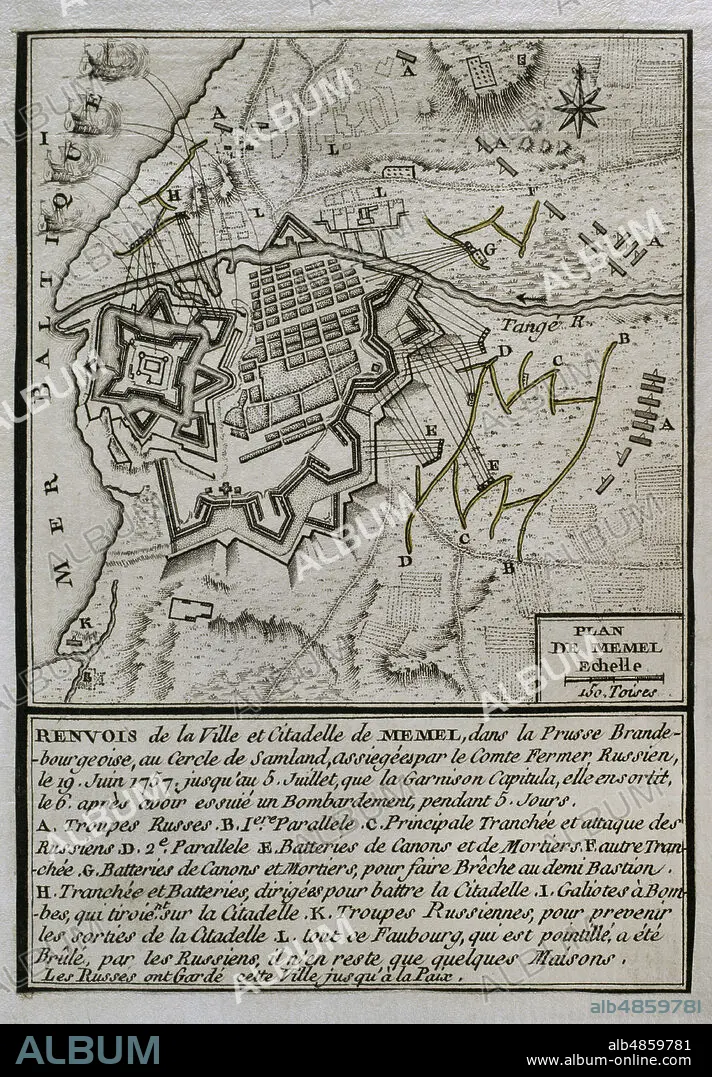
JEAN DE BEAURAIN (1696-1771). FRENCH GEOGRAPHER.. Seven Years War (1756-1763). Map of the Russian bombardment of Memel, 1757. On June 19, 1757 the Russian army, commanded by Field Marshal Stepan Fyodorovich Apraksin, besieged the town to seize one of the most strongest fortresses in Prussia. After five days of severe artillery fire, Russian troops succeeded in their assault. The garrison capitulated on 6 July and and was taken by the Russians for the rest of the war. Memel was used by the Russians as a base from which to invade East Prussia. Published in 1765 by the cartographer Jean de Beaurain (1696-1771) as an illustration of his Great Map of Germany, with the events that took place during the Seven Years War. Engraving. French edition, 1765. Military Historical Library of Barcelona (Biblioteca Histórico Militar de Barcelona). Catalonia. Spain.
| Teilen |
|---|
 Pinterest Pinterest |
 Twitter Twitter |
 Facebook Facebook |
 Link kopieren Link kopieren |
 Email Email |
|
Zu einem anderen Lightbox hinzufügen |
|
Zu einem anderen Lightbox hinzufügen |


Haben Sie bereits ein Konto? Anmelden
Sie haben kein Konto? Registrieren
Dieses Bild kaufen

Untertitel:
Siehe automatische Übersetzung
Seven Years War (1756-1763). Map of the Russian bombardment of Memel, 1757. On June 19, 1757 the Russian army, commanded by Field Marshal Stepan Fyodorovich Apraksin, besieged the town to seize one of the most strongest fortresses in Prussia. After five days of severe artillery fire, Russian troops succeeded in their assault. The garrison capitulated on 6 July and and was taken by the Russians for the rest of the war. Memel was used by the Russians as a base from which to invade East Prussia. Published in 1765 by the cartographer Jean de Beaurain (1696-1771) as an illustration of his Great Map of Germany, with the events that took place during the Seven Years War. Engraving. French edition, 1765. Military Historical Library of Barcelona (Biblioteca Histórico Militar de Barcelona). Catalonia. Spain.
Standort:
Historical Military Library of Barcelona. Catalonia. Spain.
Bildnachweis:
Album / Prisma
Freigaben (Releases):
Model: Nein - Eigentum: Nein
Rechtefragen?
Rechtefragen?
Bildgröße:
3425 x 4928 px | 48.3 MB
Druckgröße:
29.0 x 41.7 cm | 11.4 x 16.4 in (300 dpi)
Schlüsselwörter:
18. JAHRHUNDERT • 18. JH. • ARCHITEKTUR, MILITAER • BELAGERUNG • BESCHIESSUNG • BOMBARDE (MUSIKINSTRUMENT) • BOMBARDEMENT • BOMBARDIERUNG • BOMBENANGRIFF • DEUTSCHLAND • EINFALL • EUROPA • EUROPAEER (F M) • EUROPAEER • EUROPÄER (F M) • EUROPÄER • EUROPÄISCH • FEUER, KRIEG • GESCHICHTE • GESCHICHTE, PREUSSEN • GESCHICHTE, RUSSLAND • GRAVUR • HISTORICAL MILITARY LIBRARY OF BARCELONA. CATALONIA. SPAIN. • JEAN DE BEAURAIN (1696-1771). FRENCH GEOGRAPHER. • KARTE (KARTHOGRAFIE) • KARTEN • KARTHOGRAFIE • KARTHOGRAPHIE • KARTOGRAFIE (KARTE) • KARTOGRAPHIE • KONFLIKT • KONFLIKTE • KRIEG • KRIEG: BELAGERUNG • LANDKARTE • MEMEL • PLAN (KARTOGRAPHIE) • POMMER • PREUSSEN: GESCHICHTE • RUSSISCH • RUSSISCHES REICH • RUSSLAND: GESCHICHTE • SIEBENJAEHRIGER KRIEG • SIEBENJÄHRIGER KRIEG • STICH (KUNST) • STRATEGIE • WISSENSCH.: KARTOGRAPHIE • ZEITGESCHICHTE
