alb15530062
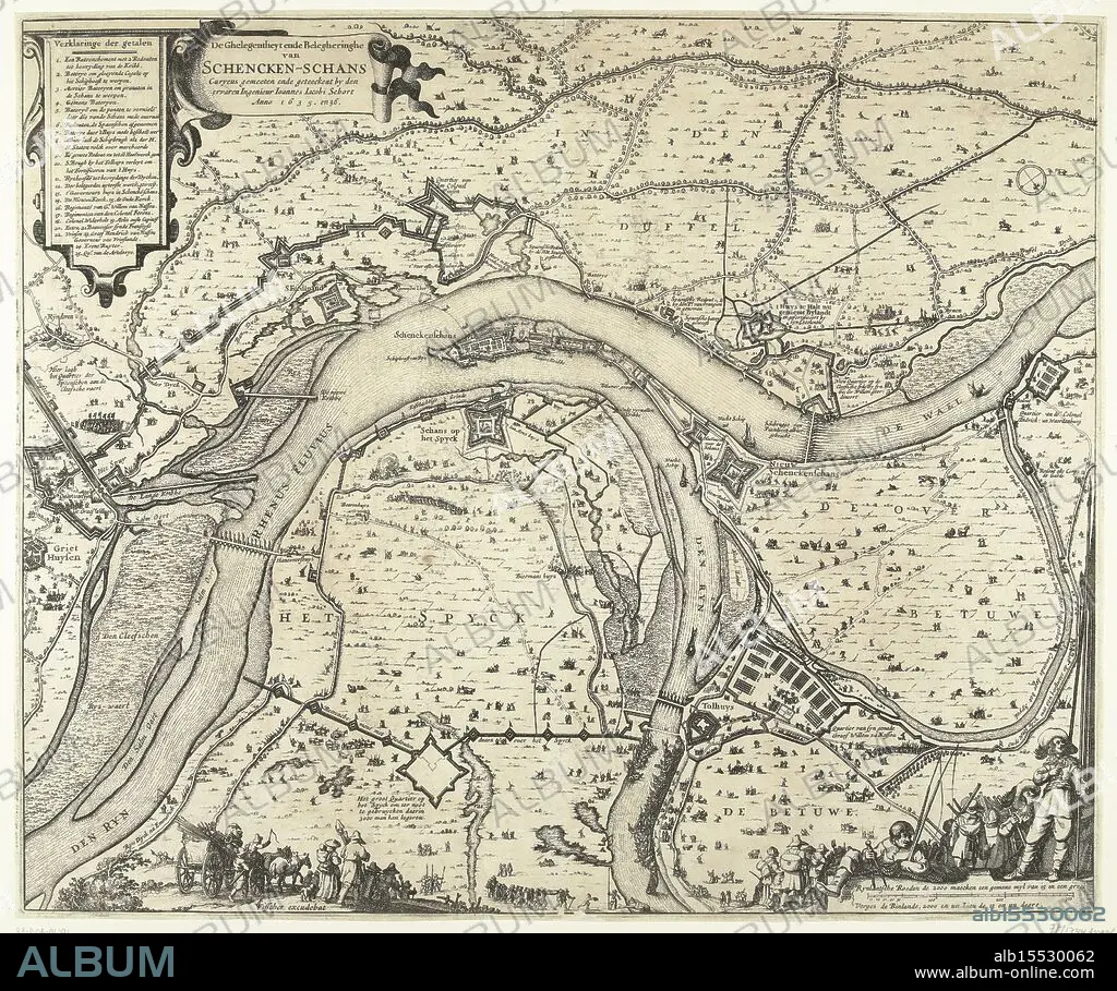
Amsterdam, Visscher, Claes Jansz. (II), Schort, Johannes Jacobus, The Siege and Besiegement of Schencken Schans Curyeus measured and drawn by the experienced Engineer Ioannes Iacobi Schort Anno 1635. and 36., Map with the siege and conquest of Schenckenschans by Frederik Hendrik, 1635-1636, Map of the siege and capture of Schenckenschans, located at the fork in the Rhine and Waal, by the States army under Frederik Hendrik, 1635-1636. Top left the title and the legend 1-25. Bottom right soldiers and a fisherman with two fishing rods and a compass. At the bottom in the foreground various figures., print, picture, map, news print, prints, pictures, Frederik Muller Historieplaten, height 473 mm, width 569 mm, Noord-Nederlands, 1586 - 1652-06-19, print maker, printmaker, 1636 - 1636, second quarter 17th century, paper, papier, etching, etchings, Nederlands, cartographer, Publication (Event), Publicatie, publisher.
| Teilen |
|---|
 Pinterest Pinterest |
 Twitter Twitter |
 Facebook Facebook |
 Link kopieren Link kopieren |
 Email Email |
|
Zu einem anderen Lightbox hinzufügen |
|
Zu einem anderen Lightbox hinzufügen |


Haben Sie bereits ein Konto? Anmelden
Sie haben kein Konto? Registrieren
Dieses Bild kaufen.
Nutzung auswählen:

Untertitel: Siehe automatische Übersetzung
Amsterdam, Visscher, Claes Jansz. (II), Schort, Johannes Jacobus, The Siege and Besiegement of Schencken Schans Curyeus measured and drawn by the experienced Engineer Ioannes Iacobi Schort Anno 1635. and 36., Map with the siege and conquest of Schenckenschans by Frederik Hendrik, 1635-1636, Map of the siege and capture of Schenckenschans, located at the fork in the Rhine and Waal, by the States army under Frederik Hendrik, 1635-1636. Top left the title and the legend 1-25. Bottom right soldiers and a fisherman with two fishing rods and a compass. At the bottom in the foreground various figures., print, picture, map, news print, prints, pictures, Frederik Muller Historieplaten, height 473 mm, width 569 mm, Noord-Nederlands, 1586 - 1652-06-19, print maker, printmaker, 1636 - 1636, second quarter 17th century, paper, papier, etching, etchings, Nederlands, cartographer, Publication (Event), Publicatie, publisher
Amsterdam, Visscher, Claes Jansz. (II), Schort, Johannes Jacobus, The Siege and Besiegement of Schencken Schans Curyeus measured and drawn by the experienced Engineer Ioannes Iacobi Schort Anno 1635. and 36., Map with the siege and conquest of Schenckenschans by Frederik Hendrik, 1635-1636, Map of the siege and capture of Schenckenschans, located at the fork in the Rhine and Waal, by the States army under Frederik Hendrik, 1635-1636. Top left the title and the legend 1-25. Bottom right soldiers and a fisherman with two fishing rods and a compass. At the bottom in the foreground various figures., print, picture, map, news print, prints, pictures, Frederik Muller Historieplaten, height 473 mm, width 569 mm, Noord-Nederlands, 1586 - 1652-06-19, print maker, printmaker, 1636 - 1636, second quarter 17th century, paper, papier, etching, etchings, Nederlands, cartographer, Publication (Event), Publicatie, publisher
Bildnachweis: Album / quintlox
Freigaben (Releases): ? Modellfreigabe: Nein - ? Eigentumsfreigabe: Nein
Rechtefragen?
Rechtefragen?
Bildgröße: 5573 × 4658 px | 74.3 MB
Druckgröße: 47.2 × 39.4 cm | 2194.1 × 1833.9 in (300 dpi)
Schlüsselwörter: ABDRUCK • AMSTERDAM • BILDER • EREIGNIS • EROBERUNG • FISCHER • GEFANGENNAHME • IN GEMAELDEN • INNENRAEUME: IN GEMAELDEN • KADER • KARTE (KARTHOGRAFIE) • KARTEN • KARTHOGRAPHIE • KARTOGRAPH • LANDKARTE • MALEN • PAPIER • PLAN (KARTOGRAPHIE) • SIEG (ERFOLG) • SIEG • TRIUMPH • VIKTORIA
