alb3848047
cyclone nargis
| Teilen |
|---|
 Pinterest Pinterest |
 Twitter Twitter |
 Facebook Facebook |
 Link kopieren Link kopieren |
 Email Email |
|
Zu einem anderen Lightbox hinzufügen |
|
Zu einem anderen Lightbox hinzufügen |


Haben Sie bereits ein Konto? Anmelden
Sie haben kein Konto? Registrieren
Dieses Bild kaufen.
Nutzung auswählen:

Titel: cyclone nargis
Untertitel: Siehe automatische Übersetzung
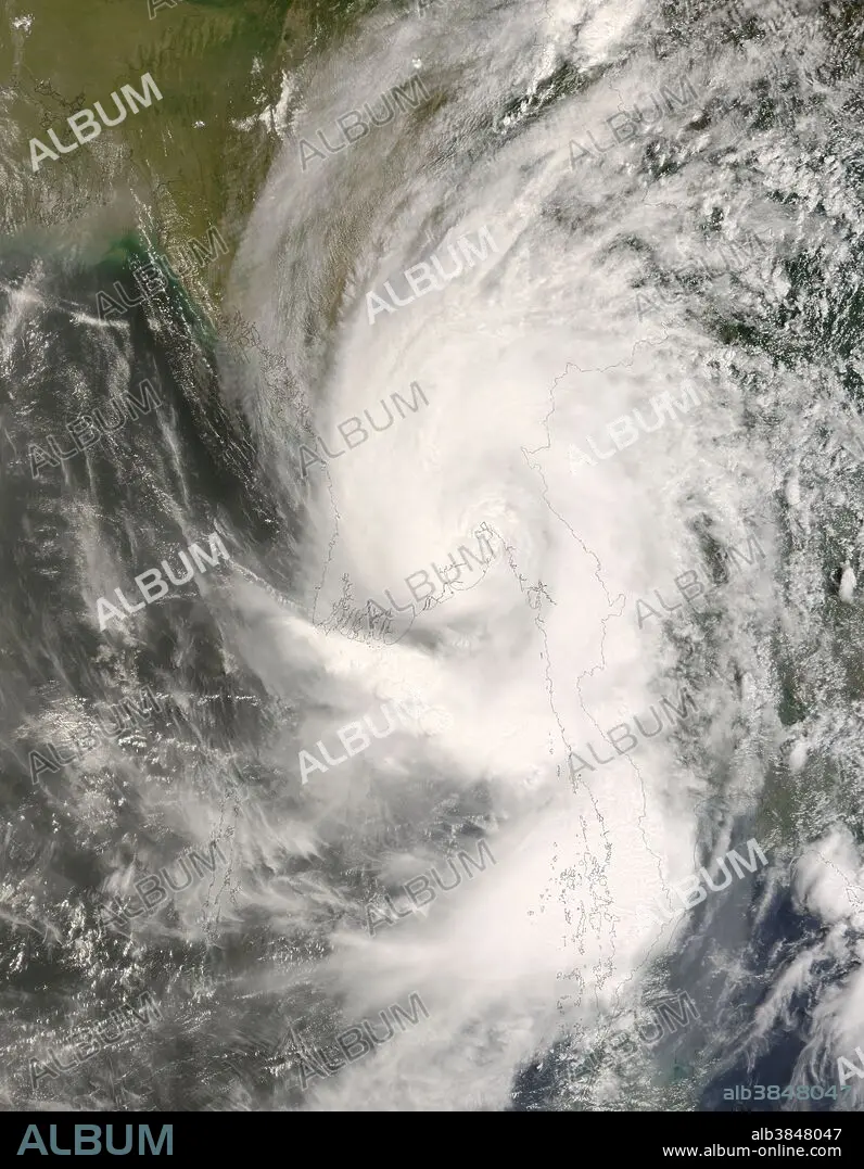
In early May 2008, Cyclone Nargis passed over Myanmar (Burma) after forming in the Bay of Bengal. At one point, Nargis was a Category 4 cyclone, with sustained winds of 210 kilometers per hour (130 miles per hour), according to Unisys Weather. This satellite view of the storm was acquired by the Moderate Resolution Imaging Spectroradiometer (MODIS) on NASA's Terra satellite. Ragged lines of thunderstorms peek up above the other clouds in a number of areas, casting shadows on lower lying clouds, evidence of intense rain systems within the storm. By the time MODIS acquired this image on May 3 at 10:55 am local time (4:25 UTC), the cyclone had weakened to tropical storm strength. While the spiral structure is still evident, the eye is poorly defined, and clouds fill the space the between spiral arms, characteristics of a less-powerful tropical storm. The typhoon lost strength before coming ashore on May 2, but it still carried very powerful winds and heavy rain. The storm's path took it almost directly over Yangon, a city with a population of more than 4 million. Extensive flooding along the coastal plains where the storm passed were clearly seen in satellite imagery taken just after the storm passed. News reports on May 9 stated that as many as 100,000 people were killed, and thousands more were missing.
In early May 2008, Cyclone Nargis passed over Myanmar (Burma) after forming in the Bay of Bengal. At one point, Nargis was a Category 4 cyclone, with sustained winds of 210 kilometers per hour (130 miles per hour), according to Unisys Weather. This satellite view of the storm was acquired by the Moderate Resolution Imaging Spectroradiometer (MODIS) on NASA's Terra satellite. Ragged lines of thunderstorms peek up above the other clouds in a number of areas, casting shadows on lower lying clouds, evidence of intense rain systems within the storm. By the time MODIS acquired this image on May 3 at 10:55 am local time (4:25 UTC), the cyclone had weakened to tropical storm strength. While the spiral structure is still evident, the eye is poorly defined, and clouds fill the space the between spiral arms, characteristics of a less-powerful tropical storm. The typhoon lost strength before coming ashore on May 2, but it still carried very powerful winds and heavy rain. The storm's path took it almost directly over Yangon, a city with a population of more than 4 million. Extensive flooding along the coastal plains where the storm passed were clearly seen in satellite imagery taken just after the storm passed. News reports on May 9 stated that as many as 100,000 people were killed, and thousands more were missing.
Kategorie: WISSENSCHAFT
Bildnachweis: Album / NASA/Science Source
Freigaben (Releases): ? Modellfreigabe: Nein - ? Eigentumsfreigabe: Nein
Rechtefragen?
Rechtefragen?
Bildgröße: 5600 × 7200 px | 115.4 MB
Druckgröße: 47.4 × 61.0 cm | 2204.7 × 2834.6 in (300 dpi)
Schlüsselwörter: ORKAN • SATELLIT • TERRA • WISSENSCHAFT
