alb4859782
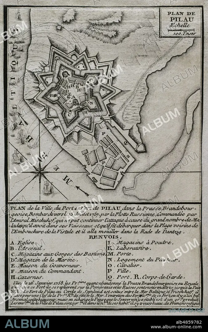
JEAN DE BEAURAIN (1696-1771). FRENCH GEOGRAPHER.. Seven Years War (1756-1763). Map of the fortress of Pillau, on the Baltic Sea. The Russian army was bombarding the fortress during 1757 and 1758, altough was forced to cease it attacks because of an excessive incidence of disease. Despite this, the Prussians abandoned the fortress in early 1758, and remained in Russian hands during the duration of the war. Published in 1765 by the cartographer Jean de Beaurain (1696-1771) as an illustration of his Great Map of Germany, with the events that took place during the Seven Years War. Engraving. French edition, 1765. Military Historical Library of Barcelona (Biblioteca Histórico Militar de Barcelona). Catalonia. Spain.
| Teilen |
|---|
 Pinterest Pinterest |
 Twitter Twitter |
 Facebook Facebook |
 Link kopieren Link kopieren |
 Email Email |
|
Zu einem anderen Lightbox hinzufügen |
|
Zu einem anderen Lightbox hinzufügen |


Haben Sie bereits ein Konto? Anmelden
Sie haben kein Konto? Registrieren
Dieses Bild kaufen.
Nutzung auswählen:

Untertitel: Siehe automatische Übersetzung
Seven Years War (1756-1763). Map of the fortress of Pillau, on the Baltic Sea. The Russian army was bombarding the fortress during 1757 and 1758, altough was forced to cease it attacks because of an excessive incidence of disease. Despite this, the Prussians abandoned the fortress in early 1758, and remained in Russian hands during the duration of the war. Published in 1765 by the cartographer Jean de Beaurain (1696-1771) as an illustration of his Great Map of Germany, with the events that took place during the Seven Years War. Engraving. French edition, 1765. Military Historical Library of Barcelona (Biblioteca Histórico Militar de Barcelona). Catalonia. Spain.
Seven Years War (1756-1763). Map of the fortress of Pillau, on the Baltic Sea. The Russian army was bombarding the fortress during 1757 and 1758, altough was forced to cease it attacks because of an excessive incidence of disease. Despite this, the Prussians abandoned the fortress in early 1758, and remained in Russian hands during the duration of the war. Published in 1765 by the cartographer Jean de Beaurain (1696-1771) as an illustration of his Great Map of Germany, with the events that took place during the Seven Years War. Engraving. French edition, 1765. Military Historical Library of Barcelona (Biblioteca Histórico Militar de Barcelona). Catalonia. Spain.
Standort: Historical Military Library of Barcelona. Catalonia. Spain.
Bildnachweis: Album / Prisma
Freigaben (Releases): ? Modellfreigabe: Nein - ? Eigentumsfreigabe: Nein
Rechtefragen?
Rechtefragen?
Bildgröße: 3307 × 5018 px | 47.5 MB
Druckgröße: 28.0 × 42.5 cm | 1302.0 × 1975.6 in (300 dpi)
Schlüsselwörter: 18. JAHRHUNDERT • 18. JH. • ARCHITEKTUR, MILITAER • BALTISK • BESCHIESSUNG • BOMBARDE (MUSIKINSTRUMENT) • BOMBARDEMENT • BOMBARDIERUNG • BOMBENANGRIFF • EUROPA • FEUER, KRIEG • GESCHICHTE • GESCHICHTE, PREUSSEN • GESCHICHTE, RUSSLAND • GRAVUR • HISTORICAL MILITARY LIBRARY OF BARCELONA. CATALONIA. SPAIN. • JEAN DE BEAURAIN (1696-1771). FRENCH GEOGRAPHER. • KARTE (KARTHOGRAFIE) • KARTEN • KARTHOGRAFIE • KARTHOGRAPHIE • KARTOGRAFIE (KARTE) • KARTOGRAPHIE • KOMPASSROSE • KRIEG • LANDKARTE • PLAN (KARTOGRAPHIE) • POMMER • PREUSSEN: GESCHICHTE • RUSSISCH • RUSSLAND • RUSSLAND: GESCHICHTE • SIEBENJAEHRIGER KRIEG • SIEBENJÄHRIGER KRIEG • STICH (KUNST) • WINDROSE • WISSENSCH.: KARTOGRAPHIE • ZEITGESCHICHTE
