alb4859079
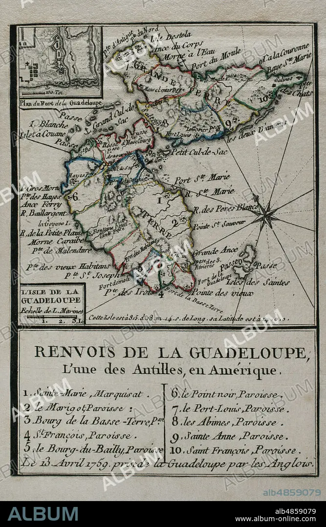
JEAN DE BEAURAIN (1696-1771). FRENCH GEOGRAPHER.. Map of Guadeloupe, 1759. Antilles Archipelago, Caribbean Sea. France took possession of the island on 28 June 1635, after landing at Pointe Allegre. During the Seven Years War, was conquered by England, founding the Port of Pointe-a-Pitre. Taking of the island of Guadeloupe by the British troops on April 13, 1759. Engraving published in 1765 by the cartographer Jean de Beaurain (1696-1771) as an illustration of his Great Map of Germany, with the events that took place during the Seven Years War. French edition, 1765. Military Historical Library of Barcelona (Biblioteca Histórico Militar de Barcelona). Catalonia. Spain.
| Teilen |
|---|
 Pinterest Pinterest |
 Twitter Twitter |
 Facebook Facebook |
 Link kopieren Link kopieren |
 Email Email |
|
Zu einem anderen Lightbox hinzufügen |
|
Zu einem anderen Lightbox hinzufügen |


Haben Sie bereits ein Konto? Anmelden
Sie haben kein Konto? Registrieren
Dieses Bild kaufen.
Nutzung auswählen:

Untertitel: Siehe automatische Übersetzung
Map of Guadeloupe, 1759. Antilles Archipelago, Caribbean Sea. France took possession of the island on 28 June 1635, after landing at Pointe Allegre. During the Seven Years War, was conquered by England, founding the Port of Pointe-a-Pitre. Taking of the island of Guadeloupe by the British troops on April 13, 1759. Engraving published in 1765 by the cartographer Jean de Beaurain (1696-1771) as an illustration of his Great Map of Germany, with the events that took place during the Seven Years War. French edition, 1765. Military Historical Library of Barcelona (Biblioteca Histórico Militar de Barcelona). Catalonia. Spain.
Map of Guadeloupe, 1759. Antilles Archipelago, Caribbean Sea. France took possession of the island on 28 June 1635, after landing at Pointe Allegre. During the Seven Years War, was conquered by England, founding the Port of Pointe-a-Pitre. Taking of the island of Guadeloupe by the British troops on April 13, 1759. Engraving published in 1765 by the cartographer Jean de Beaurain (1696-1771) as an illustration of his Great Map of Germany, with the events that took place during the Seven Years War. French edition, 1765. Military Historical Library of Barcelona (Biblioteca Histórico Militar de Barcelona). Catalonia. Spain.
Standort: Historical Military Library of Barcelona. Catalonia. Spain.
Bildnachweis: Album / Prisma
Freigaben (Releases): ? Modellfreigabe: Nein - ? Eigentumsfreigabe: Nein
Rechtefragen?
Rechtefragen?
Bildgröße: 3248 × 4990 px | 46.4 MB
Druckgröße: 27.5 × 42.2 cm | 1278.7 × 1964.6 in (300 dpi)
Schlüsselwörter: 18. JAHRHUNDERT • 18. JH. • AMERIKA • AMERIKA, KONTINENT • APRIL • ARMEE, BRITISCHE • BESCHLAGNAHME • BRITISCHE • DREIZEHN • EINFALL • ENGLAND • ENGLAND: GESCHICHTE • ENGLISCH • EROBERUNG • FEUER, KRIEG • FRANKREICH • FRANKREICH: GESCHICHTE • GESCHICHTE ENGLAND • GESCHICHTE FRANKREICH • GESCHICHTE • GESCHICHTE, ENGLAND • GESCHICHTE, FRANKREICH • GRAVUR • GROSSBRITANNIEN • HISTORICAL MILITARY LIBRARY OF BARCELONA. CATALONIA. SPAIN. • INSEL • JEAN DE BEAURAIN (1696-1771). FRENCH GEOGRAPHER. • KARIBIK • KARIBISCHES MEER • KARTE (KARTHOGRAFIE) • KARTEN • KARTHOGRAFIE • KARTHOGRAPHIE • KARTOGRAFIE (KARTE) • KARTOGRAPHIE • KOLONIALISMUS • KOLONIALKRIEGE • KOMPASSROSE • KONFLIKT • KONFLIKTE • KONTINENT: AMERIKA • KRIEG IN DEN KOLONIEN • KRIEG • LANDKARTE • PLAN (KARTOGRAPHIE) • SIEBENJAEHRIGER KRIEG • SIEBENJÄHRIGER KRIEG • SIEG (ERFOLG) • SIEG • STICH (KUNST) • TRIUMPH • VIKTORIA • WINDROSE • WISSENSCH.: KARTOGRAPHIE • ZEITGESCHICHTE
