alb3846749
Tsunami Map, Hokkaido Earthquake, 1952
| Teilen |
|---|
 Pinterest Pinterest |
 Twitter Twitter |
 Facebook Facebook |
 Link kopieren Link kopieren |
 Email Email |
|
Zu einem anderen Lightbox hinzufügen |
|
Zu einem anderen Lightbox hinzufügen |


Haben Sie bereits ein Konto? Anmelden
Sie haben kein Konto? Registrieren
Dieses Bild kaufen.
Nutzung auswählen:

Titel:
Tsunami Map, Hokkaido Earthquake, 1952
Untertitel:
Siehe automatische Übersetzung
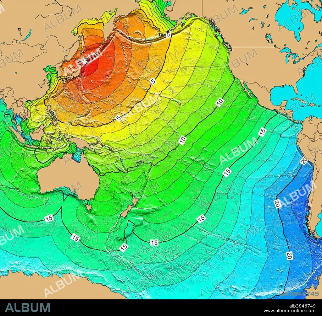
The magnitude 8.1 Mw earthquake and tsunami on March 4, 1952 off the coast of Hokkaido, Japan, did major damage in Japan. 815 homes were completely destroyed, 1,324 were partially destroyed, 6,395 were slightly damaged, 14 were burned, 91 were washed away, 328 homes and 1,621 non-residential buildings were flooded. Many ships were destroyed, and roads and railway lines were damaged. Twenty-eight people died, 5 people were missing and 287 people were injured in Japan. The tsunami was observed on tide gauges in Hawaii, the west coast of the United States, Alaska, Peru, the Marshall Islands, and Palau. Map generated using Tsunami Travel Time (TTT) software: calculates first-arrival travel times on a grid for a tsunami generated at an earthquake epicenter. Map contours: 1 hour intervals: red 1-4 hour arrival times, yellow: 5-6 hour arrival times, green: 7-14 hour arrival times, blue: 15-21 hour arrival times. Maps were generated from earthquake epicenters in the NGDC Global Historical Tsunami Database using NGDC 2 Minute Gridded Global Relief Data bathymetry. Maps do not provide the height or the strength of the wave, only the arrival times.
Kategorie:
WETTER
Bildnachweis:
Album / NOAA/Science Source
Freigaben (Releases):
Bildgröße:
3900 x 3632 px | 40.5 MB
Druckgröße:
33.0 x 30.8 cm | 13.0 x 12.1 in (300 dpi)
Schlüsselwörter:
BERÜHMT • BERÜHMTE PERSÖNLICHKEIT • EREIGNIS • GEOLOGIE • HYDROGRAPHIE • JAPAN • JAPANER • JAPANERIN • JAPANISCH • KARTE • MEER • MEERE • NOTABEL • ORMNAMENT: JAPANISCH • OZEAN • PROMINENZ • SEA • SEESTUECK (GEMAELDE) • TECHNOLOGIE • TSUNAMI • WETTER
