alb9344205
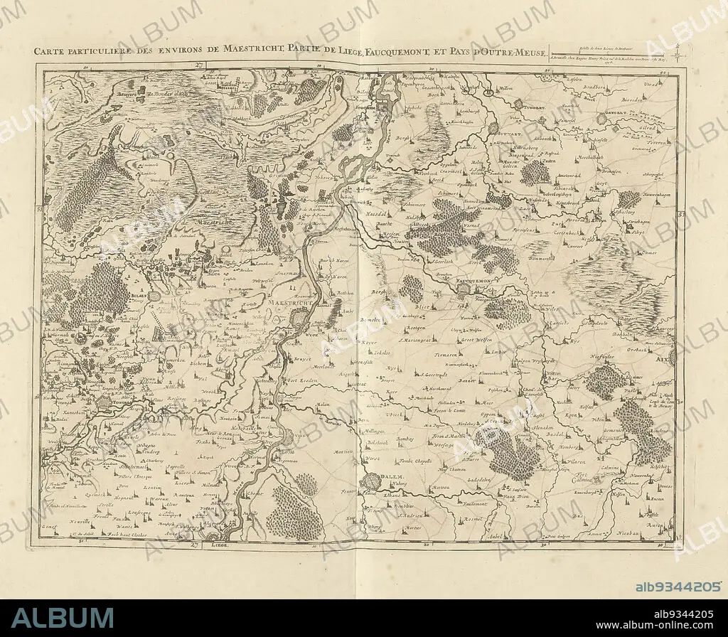
Map of Limburg with the area around Maastricht, 1708, Carte particuliere des environs de Maestricht, partie de Liege, Faucquemont, et Pays d'Outre-Meuse (title on object), Map of Limburg with the area around Maastricht, part of Liege and Valkenburg, 1708. Top right a scale bar: Echelle de deux Lieues de Brabant. The map is provided with a degree division along the edges. Part of a bundled collection of plans of battles and cities renowned in the War of the Spanish Succession. This plate is among the first 24 plates that make up a very large map of the Southern Netherlands., print maker: Jacobus Harrewijn (mentioned on object), publisher: Eugene Henry Fricx (mentioned on object), Brussels, 1708, paper, etching, engraving, height 435 mm × width 560 mm.
| Teilen |
|---|
 Pinterest Pinterest |
 Twitter Twitter |
 Facebook Facebook |
 Link kopieren Link kopieren |
 Email Email |
|
Zu einem anderen Lightbox hinzufügen |
|
Zu einem anderen Lightbox hinzufügen |


Haben Sie bereits ein Konto? Anmelden
Sie haben kein Konto? Registrieren
Dieses Bild kaufen.
Nutzung auswählen:

Untertitel:
Siehe automatische Übersetzung
Map of Limburg with the area around Maastricht, 1708, Carte particuliere des environs de Maestricht, partie de Liege, Faucquemont, et Pays d'Outre-Meuse (title on object), Map of Limburg with the area around Maastricht, part of Liege and Valkenburg, 1708. Top right a scale bar: Echelle de deux Lieues de Brabant. The map is provided with a degree division along the edges. Part of a bundled collection of plans of battles and cities renowned in the War of the Spanish Succession. This plate is among the first 24 plates that make up a very large map of the Southern Netherlands., print maker: Jacobus Harrewijn (mentioned on object), publisher: Eugene Henry Fricx (mentioned on object), Brussels, 1708, paper, etching, engraving, height 435 mm × width 560 mm
Persönlichkeiten:
Bildnachweis:
Album / quintlox
Freigaben (Releases):
Bildgröße:
4926 x 4054 px | 57.1 MB
Druckgröße:
41.7 x 34.3 cm | 16.4 x 13.5 in (300 dpi)
Schlüsselwörter:
