alb9395601
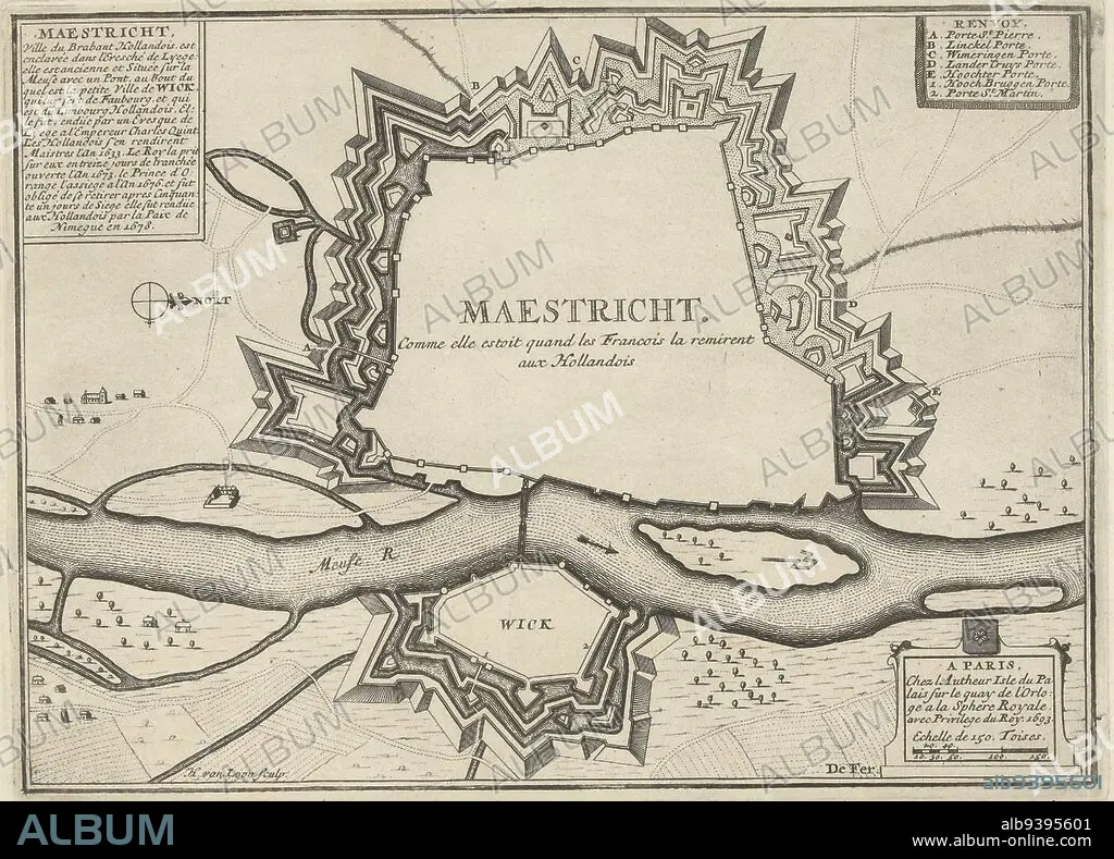
Map of the fortifications around Maastricht, besieged and captured by the French army, June 27-30, 1673. Top left a cartouche outlining the history of the city from 1633 to 1678. Top right the legend A-E and 1-2 in French, Map of Maastricht, 1673 Maestricht. Comme elle estoit quand les Francois la remirent aux Hollandois , print maker: Harmanus van Loon, (mentioned on object), publisher: unknown, Lodewijk XIV (koning van Frankrijk), (mentioned on object), Paris, 1693, paper, etching, h 200 mm × w 275 mm.
| Teilen |
|---|
 Pinterest Pinterest |
 Twitter Twitter |
 Facebook Facebook |
 Link kopieren Link kopieren |
 Email Email |
|
Zu einem anderen Lightbox hinzufügen |
|
Zu einem anderen Lightbox hinzufügen |


Haben Sie bereits ein Konto? Anmelden
Sie haben kein Konto? Registrieren
Dieses Bild kaufen.
Nutzung auswählen:

Untertitel: Siehe automatische Übersetzung
Map of the fortifications around Maastricht, besieged and captured by the French army, June 27-30, 1673. Top left a cartouche outlining the history of the city from 1633 to 1678. Top right the legend A-E and 1-2 in French, Map of Maastricht, 1673 Maestricht. Comme elle estoit quand les Francois la remirent aux Hollandois , print maker: Harmanus van Loon, (mentioned on object), publisher: unknown, Lodewijk XIV (koning van Frankrijk), (mentioned on object), Paris, 1693, paper, etching, h 200 mm × w 275 mm
Map of the fortifications around Maastricht, besieged and captured by the French army, June 27-30, 1673. Top left a cartouche outlining the history of the city from 1633 to 1678. Top right the legend A-E and 1-2 in French, Map of Maastricht, 1673 Maestricht. Comme elle estoit quand les Francois la remirent aux Hollandois , print maker: Harmanus van Loon, (mentioned on object), publisher: unknown, Lodewijk XIV (koning van Frankrijk), (mentioned on object), Paris, 1693, paper, etching, h 200 mm × w 275 mm
Bildnachweis: Album / quintlox
Freigaben (Releases): ? Modellfreigabe: Nein - ? Eigentumsfreigabe: Nein
Rechtefragen?
Rechtefragen?
Bildgröße: 4221 × 3034 px | 36.6 MB
Druckgröße: 35.7 × 25.7 cm | 1661.8 × 1194.5 in (300 dpi)
Schlüsselwörter: FRANZOESISCH • FRANZOSE • FRANZÖSIN • GESCHICHTE • KARTE (KARTHOGRAFIE) • KARTEN • KARTHOGRAPHIE • LANDKARTE • OBJEKT • PAPIER • PARIS • PARIS, FRANKREICH • PLAN (KARTOGRAPHIE) • STADT • STÄDTE • ZEITGESCHICHTE
