alb6386975
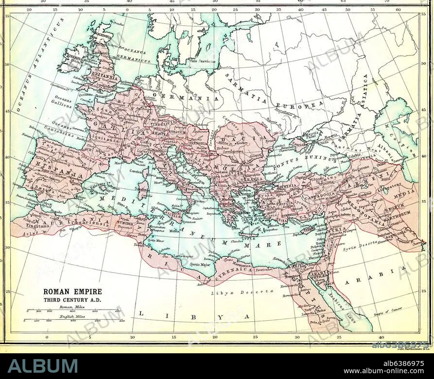
Römisches Reich im 3.Jh. / Landkarte
| Teilen |
|---|
 Pinterest Pinterest |
 Twitter Twitter |
 Facebook Facebook |
 Link kopieren Link kopieren |
 Email Email |
|
Zu einem anderen Lightbox hinzufügen |
|
Zu einem anderen Lightbox hinzufügen |


Haben Sie bereits ein Konto? Anmelden
Sie haben kein Konto? Registrieren
Dieses Bild kaufen

Titel:
Römisches Reich im 3.Jh. / Landkarte
Untertitel:
Europa / Landkarten:-"Roman Empire third century A.D.".-(Das Römische Reich im 3.Jh. n.Chr.) Aus: Atlas of the Historical Geography of the Holy Land. Designed and edited by George Adam Smith and prepared unter the direction of J.G. Bartholomew. London, Hodder and Stroughton, 1915.
Projekt:
ATLAS OF THE HISTORICAL GEOGRAPHY OF THE HOLY LA
Datum des Kunstwerks:
1915
Veranstaltungsdatum:
250
Bildnachweis:
Album / akg-images
Freigaben (Releases):
Model: Nein - Eigentum: Nein
Rechtefragen?
Rechtefragen?
Bildgröße:
2463 x 2007 px | 14.1 MB
Druckgröße:
20.9 x 17.0 cm | 8.2 x 6.7 in (300 dpi)
Schlüsselwörter:
1910ER JAHRE • 3. JAHRHUNDERT • ALLGEMEIN • ANTIKE • ATLANTEN • ATLAS OF THE HISTORICAL GEOGRAPHY OF THE HOLY LA • BARTHOLOMEW, J. G. • ERDKUNDE • EUROPA (GEOGRAPHIE) • EUROPA (KONTINENT) • GEOGRAFIE • GEOGRAPHIE • KARTE (KARTHOGRAFIE) • KARTEN • KARTHOGRAFIE • KARTHOGRAPHIE • KARTOGRAFIE (KARTE) • KARTOGRAPHIE • LANDKARTE • MITTELMEER • PERIODE: ROEM. KAISERREICH • PLAN (KARTOGRAPHIE) • ROEMISCHES REICH • ROM, KAISERLICHES • RÖMISCHES REICH • SMITH, GEORGE ADAM • TOPOGRAPHIE • WISSENSCH.: KARTOGRAPHIE • ZEHNER JAHRE
