alb3897622
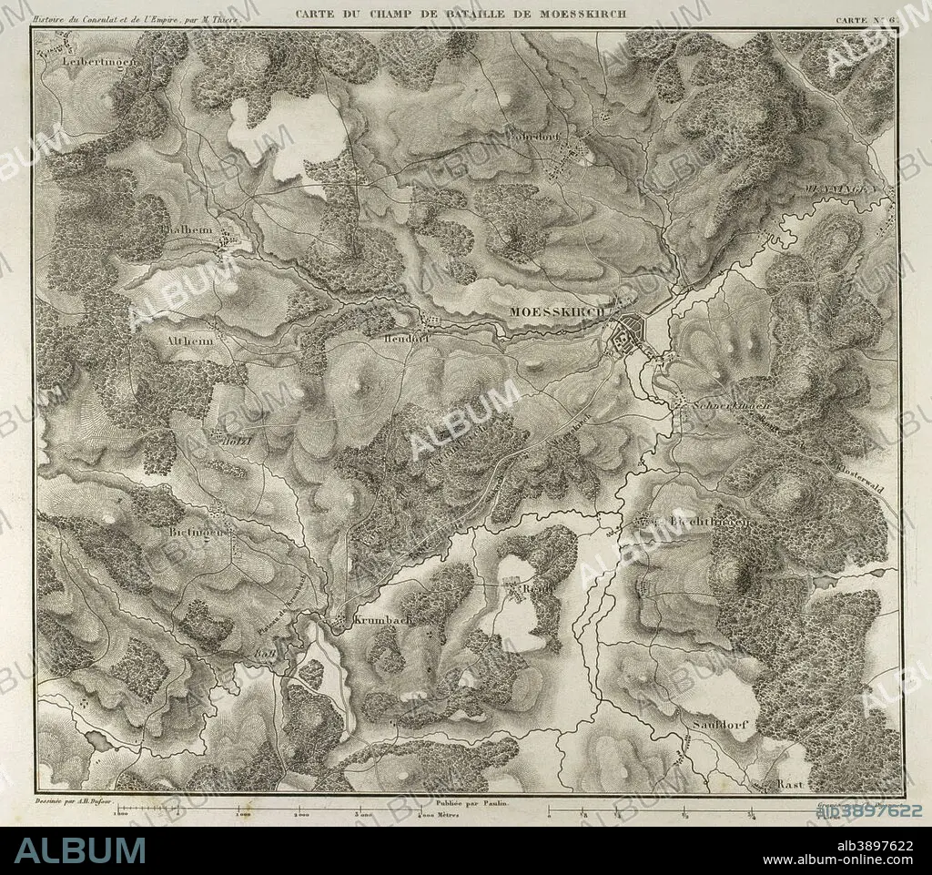
Map of the Battle of Moesskirch, 4th-5th May 1800, between the armies of France and the Holy German Roman Empire. War of the Second Coalition (context of the French Revolutionary Wars, with French victory). Atlas de l'Histoire du Consulat et de l'Empire. History of the Consulate and the Empire of France under Napoleon by Marie Joseph Louis Adolphe Thiers (1797-1877). Drawings by Dufour, engravings by Dyonnet. Edited in Paris, 1864.
| Teilen |
|---|
 Pinterest Pinterest |
 Twitter Twitter |
 Facebook Facebook |
 Link kopieren Link kopieren |
 Email Email |
|
Zu einem anderen Lightbox hinzufügen |
|
Zu einem anderen Lightbox hinzufügen |


Haben Sie bereits ein Konto? Anmelden
Sie haben kein Konto? Registrieren
Dieses Bild kaufen.
Nutzung auswählen:

Untertitel:
Siehe automatische Übersetzung
Map of the Battle of Moesskirch, 4th-5th May 1800, between the armies of France and the Holy German Roman Empire. War of the Second Coalition (context of the French Revolutionary Wars, with French victory). Atlas de l'Histoire du Consulat et de l'Empire. History of the Consulate and the Empire of France under Napoleon by Marie Joseph Louis Adolphe Thiers (1797-1877). Drawings by Dufour, engravings by Dyonnet. Edited in Paris, 1864.
Persönlichkeiten:
Bildnachweis:
Album / Prisma
Freigaben (Releases):
Bildgröße:
4134 x 3667 px | 43.4 MB
Druckgröße:
35.0 x 31.0 cm | 13.8 x 12.2 in (300 dpi)
Schlüsselwörter:
ALT (ALTER) • ALTERTÜMLICH • ANTIK • ARMEE • ARMY • EUROPA • EUROPAEER (F M) • EUROPAEER • EUROPÄER (F M) • EUROPÄER • EUROPÄISCH • FEUER, KRIEG • FRANKREICH • FRANZOESISCHE REVOLUTION (1789-99) • FRANZOESISCHE REVOLUTION • FRANZÖSISCHE REVOLUTION (1789-99) • GEOGRAFIE • GEOGRAPHIE • GESCHICHTE • GRAVUR • HEER • HISTORISCH • KARTE (KARTHOGRAFIE) • KARTEN • KARTHOGRAFIE • KARTHOGRAPHIE • KARTOGRAFIE (KARTE) • KARTOGRAPHIE • KRIEG • LANDKARTE • MAI • MESSKIRCH • NAPOLEON BONAPARTE • PLAN (KARTOGRAPHIE) • REVOLUTION 1789 • SCHLACHT VON BORODINO • SCHLACHT • STICH (KUNST) • TECHNIK: ZEICHNUNG • WISSENSCH.: KARTOGRAPHIE • ZEICHNEN • ZEICHNUNG • ZEITGESCHICHTE
