alb3838523
Typhoon Nari
| Teilen |
|---|
 Pinterest Pinterest |
 Twitter Twitter |
 Facebook Facebook |
 Link kopieren Link kopieren |
 Email Email |
|
Zu einem anderen Lightbox hinzufügen |
|
Zu einem anderen Lightbox hinzufügen |


Haben Sie bereits ein Konto? Anmelden
Sie haben kein Konto? Registrieren
Dieses Bild kaufen.
Nutzung auswählen:

Titel:
Typhoon Nari
Untertitel:
Siehe automatische Übersetzung
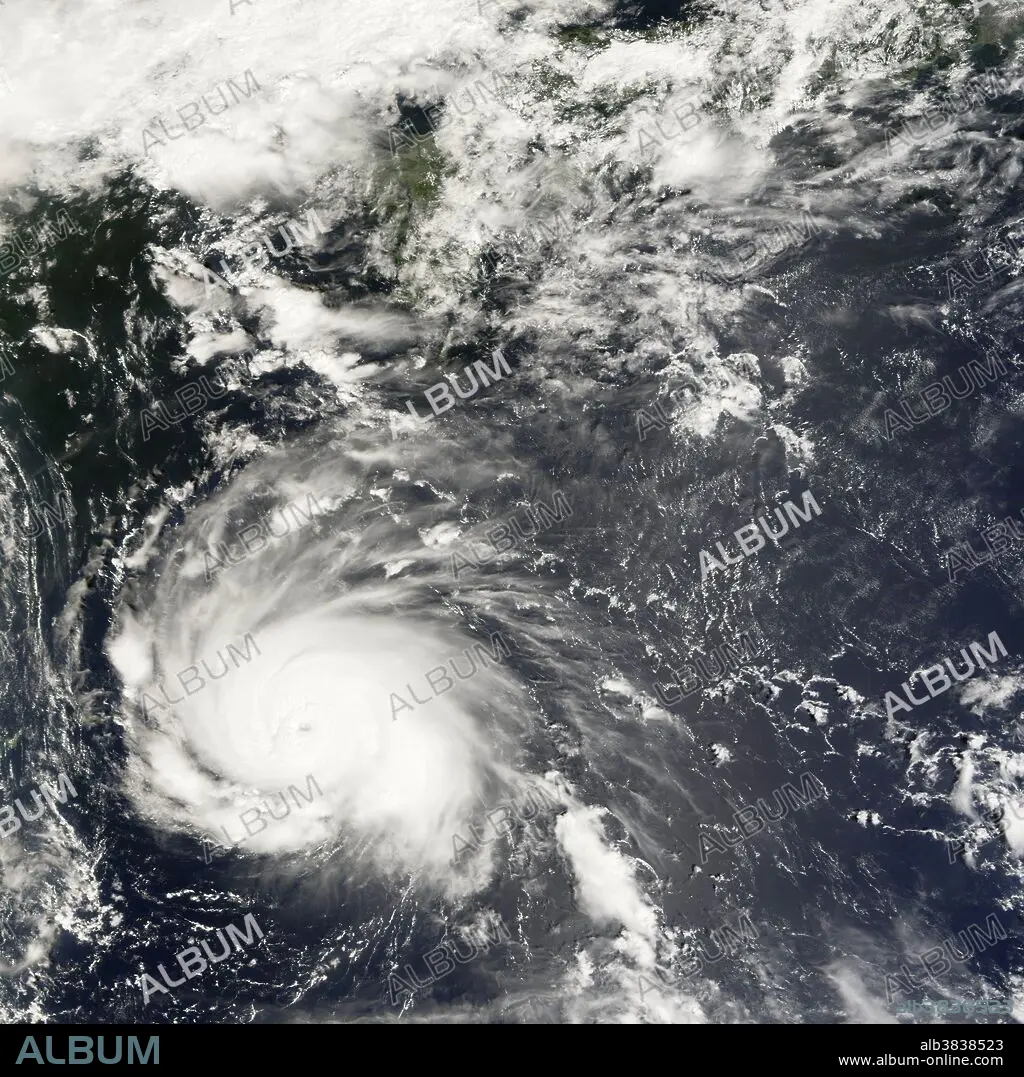
Typhoon Nari formed as a tropical storm near Okinawa on September 12, developing to typhoon strength the next day. The typhoon was forecast to swing through the East China Sea and bring stormy seas and rain to China, the Korean Peninsula, and Japan. By late in the day September 14, Nari had reached Super Typhoon status (as a Category Four strength typhoon) with peak winds measured at 220 kilometers per hour (135 miles per hour). However, the typhoon was out at sea and forecasts were calling for it to lose most of its strength well before coming ashore in Japan. The Moderate Resolution Imaging Spectroradiometer (MODIS) on NASA's Terra satellite acquired this photo-like image at 10:50 a.m. local time (01:50 UTC) on September 14, 2007. Typhoon Nari appears here as a well developed and distinct ball of circling clouds with a distinct though cloudy eye at its center. According to the Unisys Hurricane archive information, Nari had peak winds of around 120 km/hr (65 mph) and was classified a Category One typhoon.
Bildnachweis:
Album / NASA/Science Source
Freigaben (Releases):
Model: Nein - Eigentum: Nein
Rechtefragen?
Rechtefragen?
Bildgröße:
7116 x 7116 px | 144.9 MB
Druckgröße:
60.2 x 60.2 cm | 23.7 x 23.7 in (300 dpi)
Schlüsselwörter:
