alb8346596
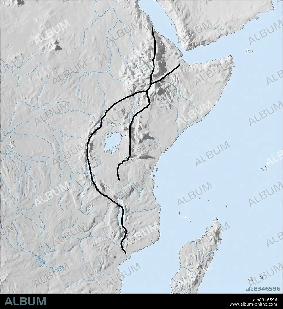
More than 4,000 km long, the Great Rift Valley tectonic fault, which includes the West and East Great Rift valleys, crosses eastern Africa from the Red Sea to the mouth of the Zambezi River. It results from the gradual separation of the Somalian lithospheric plate. This process is just beginning: in several million years, East Africa will detach itself to become an independent continent. The intense volcanic activity in the region has led to the formation of the highest mountains in Africa, such as Mount Kilimanjaro and Mount Kenya.The largest lakes in Africa (Victoria, Tanganyika, Malawi), tectonic in origin, are also situated along the Great Rift Valley. Paleontologists think that the Great Rift region was the birthplace of the first human beings, more than 2 million years ago.
| Teilen |
|---|
 Pinterest Pinterest |
 Twitter Twitter |
 Facebook Facebook |
 Link kopieren Link kopieren |
 Email Email |
|
Zu einem anderen Lightbox hinzufügen |
|
Zu einem anderen Lightbox hinzufügen |


Haben Sie bereits ein Konto? Anmelden
Sie haben kein Konto? Registrieren
Dieses Bild kaufen.
Nutzung auswählen:

Untertitel: Siehe automatische Übersetzung
More than 4,000 km long, the Great Rift Valley tectonic fault, which includes the West and East Great Rift valleys, crosses eastern Africa from the Red Sea to the mouth of the Zambezi River. It results from the gradual separation of the Somalian lithospheric plate. This process is just beginning: in several million years, East Africa will detach itself to become an independent continent. The intense volcanic activity in the region has led to the formation of the highest mountains in Africa, such as Mount Kilimanjaro and Mount Kenya.The largest lakes in Africa (Victoria, Tanganyika, Malawi), tectonic in origin, are also situated along the Great Rift Valley. Paleontologists think that the Great Rift region was the birthplace of the first human beings, more than 2 million years ago.
More than 4,000 km long, the Great Rift Valley tectonic fault, which includes the West and East Great Rift valleys, crosses eastern Africa from the Red Sea to the mouth of the Zambezi River. It results from the gradual separation of the Somalian lithospheric plate. This process is just beginning: in several million years, East Africa will detach itself to become an independent continent. The intense volcanic activity in the region has led to the formation of the highest mountains in Africa, such as Mount Kilimanjaro and Mount Kenya.The largest lakes in Africa (Victoria, Tanganyika, Malawi), tectonic in origin, are also situated along the Great Rift Valley. Paleontologists think that the Great Rift region was the birthplace of the first human beings, more than 2 million years ago.
Bildnachweis: Album / Universal Images Group
Freigaben (Releases): ? Modellfreigabe: Nein - ? Eigentumsfreigabe: Nein
Rechtefragen?
Rechtefragen?
Bildgröße: 2307 × 2400 px | 15.8 MB
Druckgröße: 19.5 × 20.3 cm | 908.3 × 944.9 in (300 dpi)
Schlüsselwörter: AFRIKA • FARBE • FARBIG • GEOGRAFIE • GEOGRAPHIE • ILLUSTRATION • ILLUSTRATIONS
