alb3793760
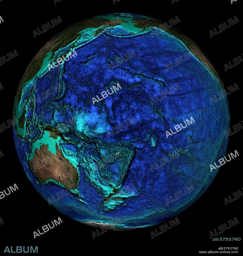
Topographical Map of Coordinates 0 N, 180 E
| Teilen |
|---|
 Pinterest Pinterest |
 Twitter Twitter |
 Facebook Facebook |
 Link kopieren Link kopieren |
 Email Email |
|
Zu einem anderen Lightbox hinzufügen |
|
Zu einem anderen Lightbox hinzufügen |


Haben Sie bereits ein Konto? Anmelden
Sie haben kein Konto? Registrieren
Dieses Bild kaufen.
Nutzung auswählen:

Titel:
Topographical Map of Coordinates 0 N, 180 E
Untertitel:
Siehe automatische Übersetzung
Topographical map of the Earth, centered on 0 degrees North, 180 degrees East. The Pacific Ocean lies here which shows numerous ocean ridges and trenches. The Mariana Trench is seen here at the bottom of the dark arc just left of center. This is the deepest point on the Earth at 10.9 kilometers below sea level. The seas and oceans are color-coded by depth and land colors are based on MODIS true-color data from the Terra satellite in 2004 where darker regions represent highlands. Turquoise regions represent the continental shelf and descend to around 150 meters before dropping off abruptly at the shelf break. The descent of the continental slope to the ocean floor is shown as increasingly dark shades of blue.
Bildnachweis:
Album / NOAA/Science Source
Freigaben (Releases):
Bildgröße:
2400 x 2400 px | 16.5 MB
Druckgröße:
20.3 x 20.3 cm | 8.0 x 8.0 in (300 dpi)
Schlüsselwörter:
GEOGRAFIE • GEOGRAPHIE • GLOBUS • KARTHOGRAFIE • KARTOGRAFIE (KARTE) • KARTOGRAPHIE • MEER • MEERE • OZEAN • OZEANOGRAPHIE • PAZIFIK • PAZIFISCHR OZEAN • PLANET ALLE • PLANET • SEA • SEESTUECK (GEMAELDE) • TERRA • TOPOGRAPHIE • WELTKUGEL • WISSENSCH.: KARTOGRAPHIE
