alb4440350
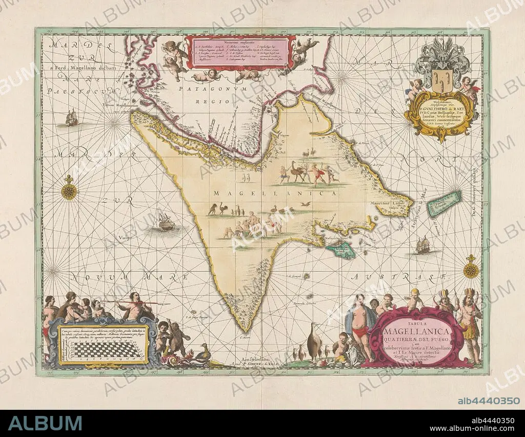
Map of Fire Land, Tabula Magellanica in terms of Tierrae del Fuego (title on object), Map of Fire Land and the Strait of Magellan, bordered in green, areas colored. Two compass roses, ships in the sea, images of hunting and eating people and birds on the land. Bottom left the bowl and bottom right the title cartouche surrounded by inhabitants of Vuurland, penguins and shells. At the top right the order from Johannes Janssonius to Gualtherus de Raet, with coat of arms and helmet, flanked by two putti, maps or separate countries or regions, Vuurland, Magellan Street, Pieter Schenk (I) (mentioned on object), 1680 - 1711, paper, engraving, h 410 mm × w 536 mm.
| Teilen |
|---|
 Pinterest Pinterest |
 Twitter Twitter |
 Facebook Facebook |
 Link kopieren Link kopieren |
 Email Email |
|
Zu einem anderen Lightbox hinzufügen |
|
Zu einem anderen Lightbox hinzufügen |


Haben Sie bereits ein Konto? Anmelden
Sie haben kein Konto? Registrieren
Dieses Bild kaufen.
Nutzung auswählen:

Untertitel: Siehe automatische Übersetzung
Map of Fire Land, Tabula Magellanica in terms of Tierrae del Fuego (title on object), Map of Fire Land and the Strait of Magellan, bordered in green, areas colored. Two compass roses, ships in the sea, images of hunting and eating people and birds on the land. Bottom left the bowl and bottom right the title cartouche surrounded by inhabitants of Vuurland, penguins and shells. At the top right the order from Johannes Janssonius to Gualtherus de Raet, with coat of arms and helmet, flanked by two putti, maps or separate countries or regions, Vuurland, Magellan Street, Pieter Schenk (I) (mentioned on object), 1680 - 1711, paper, engraving, h 410 mm × w 536 mm
Map of Fire Land, Tabula Magellanica in terms of Tierrae del Fuego (title on object), Map of Fire Land and the Strait of Magellan, bordered in green, areas colored. Two compass roses, ships in the sea, images of hunting and eating people and birds on the land. Bottom left the bowl and bottom right the title cartouche surrounded by inhabitants of Vuurland, penguins and shells. At the top right the order from Johannes Janssonius to Gualtherus de Raet, with coat of arms and helmet, flanked by two putti, maps or separate countries or regions, Vuurland, Magellan Street, Pieter Schenk (I) (mentioned on object), 1680 - 1711, paper, engraving, h 410 mm × w 536 mm
Persönlichkeiten: PIETER SCHENK
Bildnachweis: Album / quintlox
Freigaben (Releases): ? Modellfreigabe: Nein - ? Eigentumsfreigabe: Nein
Rechtefragen?
Rechtefragen?
Bildgröße: 5742 × 4481 px | 73.6 MB
Druckgröße: 48.6 × 37.9 cm | 2260.6 × 1764.2 in (300 dpi)
Schlüsselwörter: GRAVUR • GRUEN • GRÜN • HELM • JAGD • KARTE (KARTHOGRAFIE) • KARTEN • KARTHOGRAPHIE • LANDKARTE • MANTEL • MEER • MEERE • OBJEKT • OZEAN • PALETOT • PAPIER • PIETER SCHENK • PLAN (KARTOGRAPHIE) • REGIONEN • SCHALE • SCHUTZHELM • SEA • SEESTUECK (GEMAELDE) • STICH (KUNST)
