alb4478645
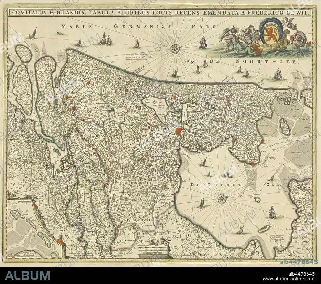
Map of county Holland, Comitatus Hollandiae tabula pluribus locis recens emendata (title on object), Map of the county of Holland on a scale of 1: 300 000, north on the right. Above right the weapon of Holland on a boat pulled by sea creatures. Bottom left a deployment with the Wadden Islands Texel, Vlieland, Terschelling and part of Ameland, maps of separate countries or regions, Holland, Noord-Holland, Zuid-Holland, Frederik de Wit (mentioned on object), c. 1670, paper, engraving, h 463 mm × w 563 mm.
| Teilen |
|---|
 Pinterest Pinterest |
 Twitter Twitter |
 Facebook Facebook |
 Link kopieren Link kopieren |
 Email Email |
|
Zu einem anderen Lightbox hinzufügen |
|
Zu einem anderen Lightbox hinzufügen |


Haben Sie bereits ein Konto? Anmelden
Sie haben kein Konto? Registrieren
Dieses Bild kaufen

Untertitel:
Siehe automatische Übersetzung
Map of county Holland, Comitatus Hollandiae tabula pluribus locis recens emendata (title on object), Map of the county of Holland on a scale of 1: 300 000, north on the right. Above right the weapon of Holland on a boat pulled by sea creatures. Bottom left a deployment with the Wadden Islands Texel, Vlieland, Terschelling and part of Ameland, maps of separate countries or regions, Holland, Noord-Holland, Zuid-Holland, Frederik de Wit (mentioned on object), c. 1670, paper, engraving, h 463 mm × w 563 mm
Bildnachweis:
Album / quintlox
Freigaben (Releases):
Model: Nein - Eigentum: Nein
Rechtefragen?
Rechtefragen?
Bildgröße:
5359 x 4468 px | 68.5 MB
Druckgröße:
45.4 x 37.8 cm | 17.9 x 14.9 in (300 dpi)
Schlüsselwörter:
GRAVUR • HOLLAND • KARTE (KARTHOGRAFIE) • KARTEN • KARTHOGRAPHIE • LANDKARTE • NORDEN • OBJEKT • PAPIER • PLAN (KARTOGRAPHIE) • REGIONEN • STICH (KUNST) • WAFFE • WAFFEN
