alb3836245
Yucatan Peninsula, Mexico
| Teilen |
|---|
 Pinterest Pinterest |
 Twitter Twitter |
 Facebook Facebook |
 Link kopieren Link kopieren |
 Email Email |
|
Zu einem anderen Lightbox hinzufügen |
|
Zu einem anderen Lightbox hinzufügen |


Haben Sie bereits ein Konto? Anmelden
Sie haben kein Konto? Registrieren
Dieses Bild kaufen.
Nutzung auswählen:

Titel: Yucatan Peninsula, Mexico
Untertitel: Siehe automatische Übersetzung
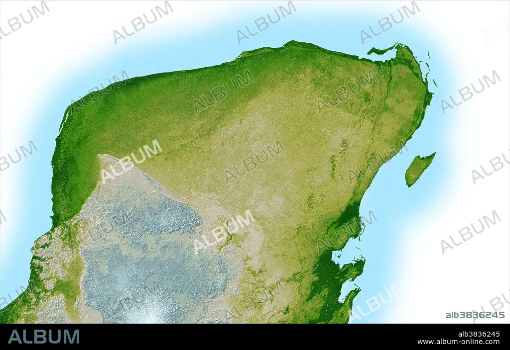
This shaded relief image of Mexico's Yucatan Peninsula show a subtle, but unmistakable, indication of the Chicxulub impact crater. Most scientists now agree that this impact was the cause of the Cretatious-Tertiary Extinction, the event 65 million years ago that marked the sudden extinction of the dinosaurs as well as the majority of life then on Earth. Most of the peninsula is visible here, along with the island of Cozumel off the east coast. The Yucatan is a plateau composed mostly of limestone and is an area of very low relief with elevations varying by less than 500 feet. In this computer-enhanced image the topography has been greatly exaggerated to highlight a semicircular trough, the darker green arcing line at the upper left corner of the peninsula. This trough is only about 10 to 15 feet deep and about 3 miles, so subtle that if you walked across it you probably would not notice it, and is a surface expression of the crater's outer boundary.
This shaded relief image of Mexico's Yucatan Peninsula show a subtle, but unmistakable, indication of the Chicxulub impact crater. Most scientists now agree that this impact was the cause of the Cretatious-Tertiary Extinction, the event 65 million years ago that marked the sudden extinction of the dinosaurs as well as the majority of life then on Earth. Most of the peninsula is visible here, along with the island of Cozumel off the east coast. The Yucatan is a plateau composed mostly of limestone and is an area of very low relief with elevations varying by less than 500 feet. In this computer-enhanced image the topography has been greatly exaggerated to highlight a semicircular trough, the darker green arcing line at the upper left corner of the peninsula. This trough is only about 10 to 15 feet deep and about 3 miles, so subtle that if you walked across it you probably would not notice it, and is a surface expression of the crater's outer boundary.
Kategorie: WISSENSCHAFT
Bildnachweis: Album / Science Source / NASA/JPL
Freigaben (Releases): ? Modellfreigabe: Nein - ? Eigentumsfreigabe: Nein
Rechtefragen?
Rechtefragen?
Bildgröße: 7200 × 4575 px | 94.2 MB
Druckgröße: 61.0 × 38.7 cm | 2834.6 × 1801.2 in (300 dpi)
Schlüsselwörter: GEOGRAFIE • GEOGRAPHIE • GEOLOGIE • HALBINSEL • KRATER (GEOLOGIE) • TOPOGRAPHIE • WISSENSCHAFT
