alb3808470
First Transatlantic Telegraph Cable, Chart, 1858
| Teilen |
|---|
 Pinterest Pinterest |
 Twitter Twitter |
 Facebook Facebook |
 Link kopieren Link kopieren |
 Email Email |
|
Zu einem anderen Lightbox hinzufügen |
|
Zu einem anderen Lightbox hinzufügen |


Haben Sie bereits ein Konto? Anmelden
Sie haben kein Konto? Registrieren
Dieses Bild kaufen.
Nutzung auswählen:

Titel: First Transatlantic Telegraph Cable, Chart, 1858
Untertitel: Siehe automatische Übersetzung
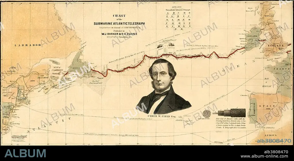
Chart of the path of the first transatlantic telegraph cable, laid in 1858. One of the 19th century's great technological achievements was to lay a telegraphic cable beneath the Atlantic, allowing messages to speed back and forth between North America and Europe in minutes, rather than ten or twelve days by steamer. An initially successful attempt in 1858, led by Cyrus W. Field (portrait on map) and financed by the Atlantic Telegraph Company, failed after three weeks. Two working cables were finally laid in July and September 1866, the result of repeated efforts by the indefatigable Field, a cadre of engineers, technicians, and sailors, two groups of financial backers, and significant help from the British and United States navies. The cable ran from Telegraph Field, Foilhommerum Bay, Valentia Island in western Ireland to Heart's Content in eastern Newfoundland.
Chart of the path of the first transatlantic telegraph cable, laid in 1858. One of the 19th century's great technological achievements was to lay a telegraphic cable beneath the Atlantic, allowing messages to speed back and forth between North America and Europe in minutes, rather than ten or twelve days by steamer. An initially successful attempt in 1858, led by Cyrus W. Field (portrait on map) and financed by the Atlantic Telegraph Company, failed after three weeks. Two working cables were finally laid in July and September 1866, the result of repeated efforts by the indefatigable Field, a cadre of engineers, technicians, and sailors, two groups of financial backers, and significant help from the British and United States navies. The cable ran from Telegraph Field, Foilhommerum Bay, Valentia Island in western Ireland to Heart's Content in eastern Newfoundland.
Bildnachweis: Album / LOC/Science Source
Freigaben (Releases): ? Modellfreigabe: Nein - ? Eigentumsfreigabe: Nein
Rechtefragen?
Rechtefragen?
Bildgröße: 7126 × 3540 px | 72.2 MB
Druckgröße: 60.3 × 30.0 cm | 2805.5 × 1393.7 in (300 dpi)
Schlüsselwörter: ABDRUCK • ILLUSTRATION • ILLUSTRATIONS • KARTE • KOMMUNIKATION • MEER • MEERE • OZEAN • PERSON • SEA • SEESTUECK (GEMAELDE) • TECHNOLOGIE
