alb3907899
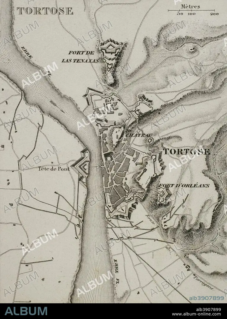
Napoleonic map. City of Tortosa (Catalonia, Spain). French troops sieged the town in December 1810. Peninsular War, part of the Napoleonic Wars. Atlas de l'Histoire du Consulat et de l'Empire. History of the Consulate and the Empire of France under Napoleon by Marie Joseph Louis Adolphe Thiers (1797-1877). Drawings by Dufour, engravings by Dyonnet. Edited in Paris, 1864.
| Teilen |
|---|
 Pinterest Pinterest |
 Twitter Twitter |
 Facebook Facebook |
 Link kopieren Link kopieren |
 Email Email |
|
Zu einem anderen Lightbox hinzufügen |
|
Zu einem anderen Lightbox hinzufügen |


Haben Sie bereits ein Konto? Anmelden
Sie haben kein Konto? Registrieren
Dieses Bild kaufen.
Nutzung auswählen:

Untertitel:
Siehe automatische Übersetzung
Napoleonic map. City of Tortosa (Catalonia, Spain). French troops sieged the town in December 1810. Peninsular War, part of the Napoleonic Wars. Atlas de l'Histoire du Consulat et de l'Empire. History of the Consulate and the Empire of France under Napoleon by Marie Joseph Louis Adolphe Thiers (1797-1877). Drawings by Dufour, engravings by Dyonnet. Edited in Paris, 1864.
Persönlichkeiten:
Bildnachweis:
Album / Prisma
Freigaben (Releases):
Bildgröße:
3130 x 4180 px | 37.4 MB
Druckgröße:
26.5 x 35.4 cm | 10.4 x 13.9 in (300 dpi)
Schlüsselwörter:
ALT (ALTER) • ALTERTÜMLICH • ANTIK • ARMEE • ARMY • EROBERUNG • EUROPA • EUROPAEER (F M) • EUROPAEER • EUROPÄER (F M) • EUROPÄER • EUROPÄISCH • FEUER, KRIEG • FRANKREICH • GEOGRAFIE • GEOGRAPHIE • GESCHICHTE • GRAVUR • HEER • ILLUSTRATION • ILLUSTRATIONS • KARTE (KARTHOGRAFIE) • KARTEN • KARTHOGRAFIE • KARTHOGRAPHIE • KARTOGRAFIE (KARTE) • KARTOGRAPHIE • KATALONIEN • KRIEG • KRIEG, NAPOLEONISCH • LANDKARTE • NAPOLEON BONAPARTE • NAPOLEONISCHE KRIEGE • NAPOLEONISCHER KRIEG • PLAN (KARTOGRAPHIE) • SIEG (ERFOLG) • SIEG • SPANIEN • STICH (KUNST) • TECHNIK: ZEICHNUNG • TORTOSA • TRIUMPH • VIKTORIA • WISSENSCH.: KARTOGRAPHIE • ZEICHNEN • ZEICHNUNG • ZEITGESCHICHTE
