alb2994765
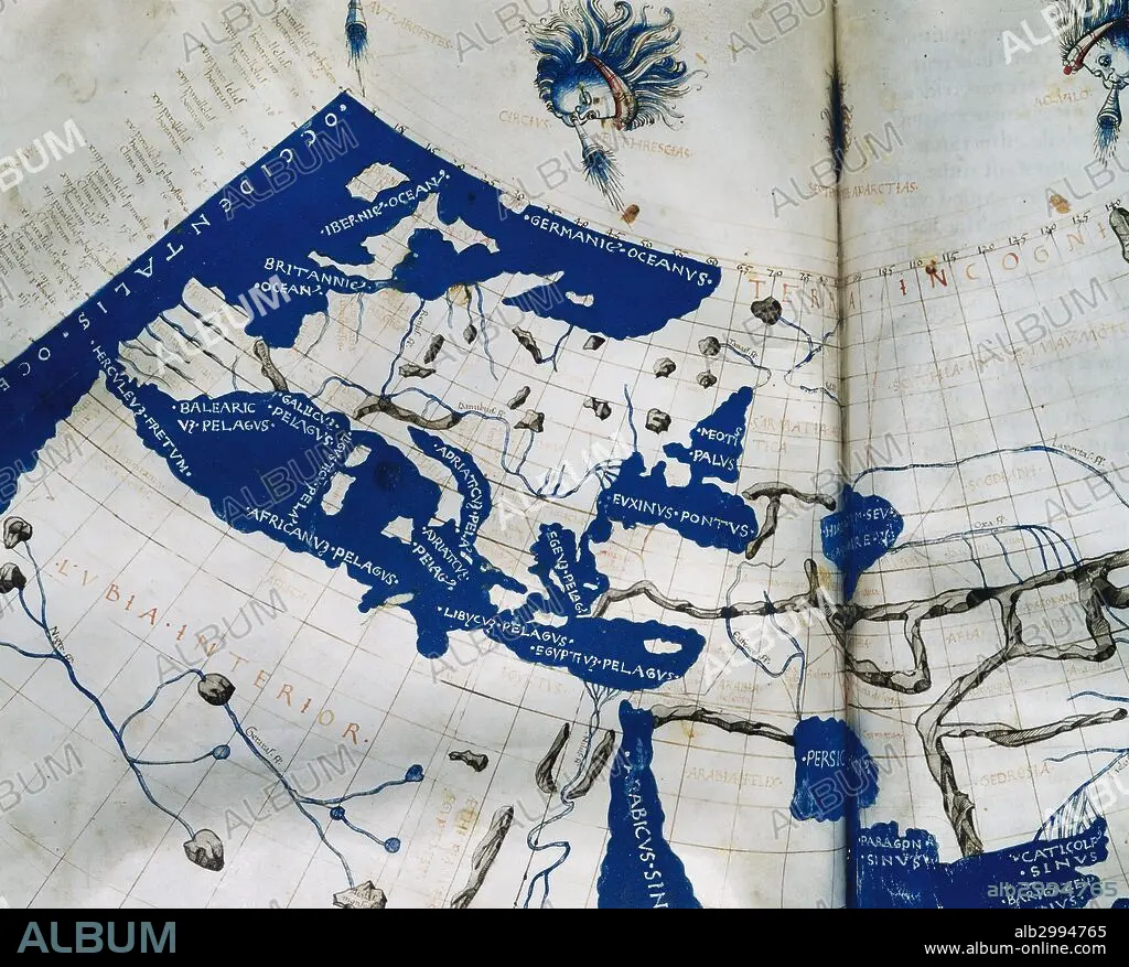
Manuscript copy of the Ptolemy (100-170 AD) world map, reconstituted from Ptolemy's Geography (c.150), indicating the countries of "Serica" and "Sinae" (China) at the extreme east, beyond the island of "Taprobane" (Sri Lanka, oversized) and the "Aurea Chersonesus" (Malay Peninsula). 15th-century.
| Teilen |
|---|
 Pinterest Pinterest |
 Twitter Twitter |
 Facebook Facebook |
 Link kopieren Link kopieren |
 Email Email |
|
Zu einem anderen Lightbox hinzufügen |
|
Zu einem anderen Lightbox hinzufügen |


Haben Sie bereits ein Konto? Anmelden
Sie haben kein Konto? Registrieren
Dieses Bild kaufen.
Nutzung auswählen:

Untertitel: Siehe automatische Übersetzung
Manuscript copy of the Ptolemy (100-170 AD) world map, reconstituted from Ptolemy's Geography (c.150), indicating the countries of "Serica" and "Sinae" (China) at the extreme east, beyond the island of "Taprobane" (Sri Lanka, oversized) and the "Aurea Chersonesus" (Malay Peninsula). 15th-century.
Manuscript copy of the Ptolemy (100-170 AD) world map, reconstituted from Ptolemy's Geography (c.150), indicating the countries of "Serica" and "Sinae" (China) at the extreme east, beyond the island of "Taprobane" (Sri Lanka, oversized) and the "Aurea Chersonesus" (Malay Peninsula). 15th-century.
Persönlichkeiten: GRECO-EGYPTIAN
Bildnachweis: Album / Prisma
Freigaben (Releases): ? Modellfreigabe: Nein - ? Eigentumsfreigabe: Nein
Rechtefragen?
Rechtefragen?
Bildgröße: 5123 × 4121 px | 60.4 MB
Druckgröße: 43.4 × 34.9 cm | 2016.9 × 1622.4 in (300 dpi)
Schlüsselwörter: 15. JAHRHUNDERT • 15. JH. • 2. JAHRHUNDERT • ALT (ALTER) • ALTERTÜMLICH • ANTIK • ANTIKE • ASIEN • ASIEN, KONTINENT • ASTROLOGE • ASTRONOMIE • EUROPA • FLUSS • GEOGRAFIE • GEOGRAPH • GEOGRAPHIE • GESCHICHTE • GRAVUR • GRECO-EGYPTIAN • HANDSCHRIFT • HISTORISCH • INSEL • KARTE (KARTHOGRAFIE) • KARTEN • KARTHOGRAFIE • KARTHOGRAPHIE • KARTOGRAFIE (KARTE) • KARTOGRAPHIE • KONTINENT, ASIEN • LANDKARTE • MANUSKRIPT • MITTELMEER • MYTHEN: PERSISCH • NORDAFRIKA • PERSISCH • PERSISCHE MYTHEN • PERSISCHE • PLAN (KARTOGRAPHIE) • SRI LANKA • STICH (KUNST) • WELTKARTE • WISSENSCH.: ASTRONOMIE • WISSENSCH.: KARTOGRAPHIE • ZEITGESCHICHTE
