alb5409647
Cantino World Map, 1502
| Teilen |
|---|
 Pinterest Pinterest |
 Twitter Twitter |
 Facebook Facebook |
 Link kopieren Link kopieren |
 Email Email |
|
Zu einem anderen Lightbox hinzufügen |
|
Zu einem anderen Lightbox hinzufügen |


Haben Sie bereits ein Konto? Anmelden
Sie haben kein Konto? Registrieren
Dieses Bild kaufen.
Nutzung auswählen:

Titel:
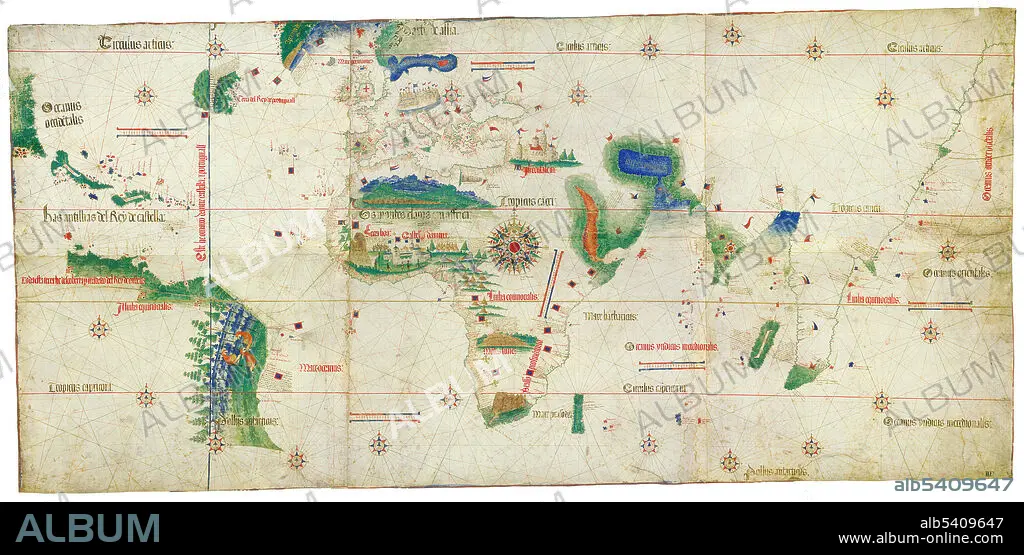
Cantino World Map, 1502
Untertitel:
Siehe automatische Übersetzung
The Cantino planisphere or Cantino world map is the earliest surviving map showing Portuguese geographic discoveries in the east and west. It is named after Alberto Cantino, an agent for the Duke of Ferrara, who successfully smuggled it from Portugal to Italy in 1502. The map is notable for portraying a fragmentary record of the Brazilian coast, and for depicting the African coast of the Atlantic and Indian Oceans with a remarkable accuracy and detail. It contains unique historical information about the maritime exploration and the evolution of nautical cartography. The Cantino planisphere is the earliest extant nautical chart where places (in Africa and parts of Brazil and India) are depicted according to their astronomically observed latitudes. While it enlightened the Italians to many new territories yet unknown to them, it was obsolete within months due to subsequent mapping voyages by the Portuguese.
Bildnachweis:
Album / Science Source
Freigaben (Releases):
Model: Nein - Eigentum: Nein
Rechtefragen?
Rechtefragen?
Bildgröße:
5370 x 2631 px | 40.4 MB
Druckgröße:
45.5 x 22.3 cm | 17.9 x 8.8 in (300 dpi)
Schlüsselwörter:
16. JAHRHUNDERT • 16. JH. • BERÜHMT • BERÜHMTE PERSÖNLICHKEIT • ENTDECKUNG • ERKUNDUNG • GEOGRAFIE • GEOGRAPHIE • KARTE • KARTHOGRAFIE • KARTOGRAFIE (KARTE) • KARTOGRAPHIE • NAVIGATION • NOTABEL • PROMINENZ • WELT • WISSENSCH.: KARTOGRAPHIE
