alb4859284
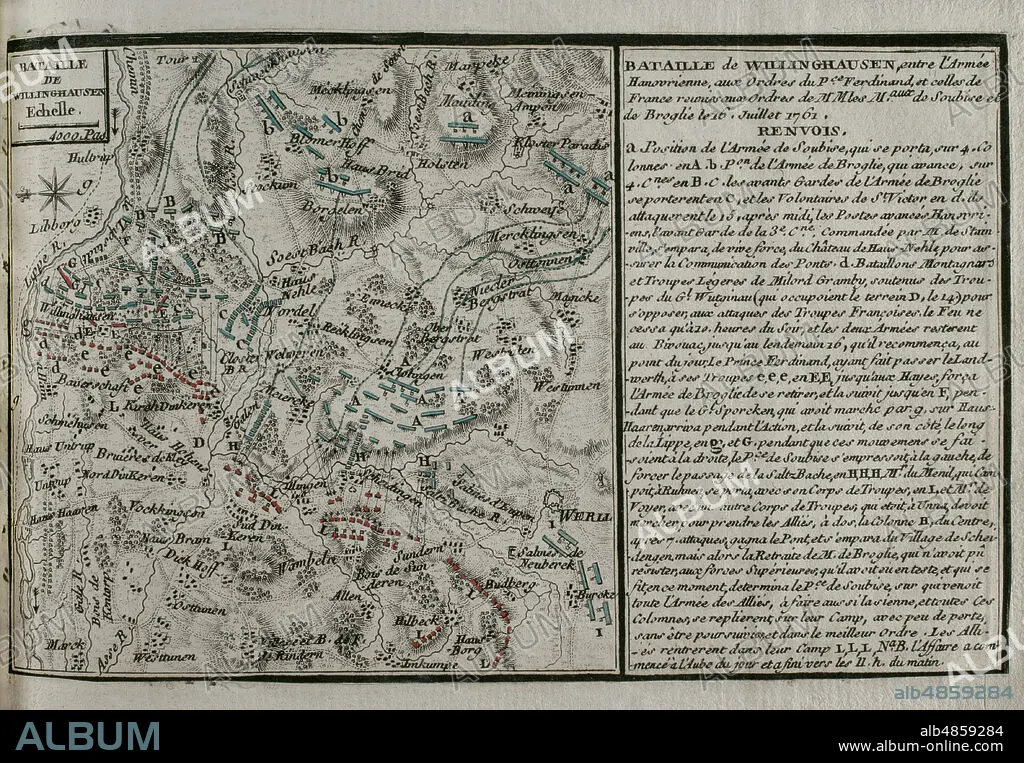
JEAN DE BEAURAIN (1696-1771). FRENCH GEOGRAPHER.. Seven Years War (1756-1763). Map of the Battle of Vellinghausen (July 15-16, 1761). It took place on the banks of the Lippe River in North West Germany. Confronted the allied Prussian-Hanoverian-British army led by Prince Ferdinand of Brunswick against the French army under the command of the Duc de Broglie and the Prince Soubise. The French force had to retreat. Published in 1765 by the cartographer Jean de Beaurain (1696-1771) as an illustration of his Great Map of Germany, with the events that took place during the Seven Years War. Allied army in red and the French army in blue. Etching and engraving. French edition, 1765. Military Historical Library of Barcelona (Biblioteca Histórico Militar de Barcelona). Catalonia. Spain.
| Teilen |
|---|
 Pinterest Pinterest |
 Twitter Twitter |
 Facebook Facebook |
 Link kopieren Link kopieren |
 Email Email |
|
Zu einem anderen Lightbox hinzufügen |
|
Zu einem anderen Lightbox hinzufügen |


Haben Sie bereits ein Konto? Anmelden
Sie haben kein Konto? Registrieren
Dieses Bild kaufen.
Nutzung auswählen:

Untertitel: Siehe automatische Übersetzung
Seven Years War (1756-1763). Map of the Battle of Vellinghausen (July 15-16, 1761). It took place on the banks of the Lippe River in North West Germany. Confronted the allied Prussian-Hanoverian-British army led by Prince Ferdinand of Brunswick against the French army under the command of the Duc de Broglie and the Prince Soubise. The French force had to retreat. Published in 1765 by the cartographer Jean de Beaurain (1696-1771) as an illustration of his Great Map of Germany, with the events that took place during the Seven Years War. Allied army in red and the French army in blue. Etching and engraving. French edition, 1765. Military Historical Library of Barcelona (Biblioteca Histórico Militar de Barcelona). Catalonia. Spain.
Seven Years War (1756-1763). Map of the Battle of Vellinghausen (July 15-16, 1761). It took place on the banks of the Lippe River in North West Germany. Confronted the allied Prussian-Hanoverian-British army led by Prince Ferdinand of Brunswick against the French army under the command of the Duc de Broglie and the Prince Soubise. The French force had to retreat. Published in 1765 by the cartographer Jean de Beaurain (1696-1771) as an illustration of his Great Map of Germany, with the events that took place during the Seven Years War. Allied army in red and the French army in blue. Etching and engraving. French edition, 1765. Military Historical Library of Barcelona (Biblioteca Histórico Militar de Barcelona). Catalonia. Spain.
Standort: Historical Military Library of Barcelona. Catalonia. Spain.
Bildnachweis: Album / Prisma
Freigaben (Releases): ? Modellfreigabe: Nein - ? Eigentumsfreigabe: Nein
Rechtefragen?
Rechtefragen?
Bildgröße: 4724 × 3277 px | 44.3 MB
Druckgröße: 40.0 × 27.7 cm | 1859.8 × 1290.2 in (300 dpi)
Schlüsselwörter: 18. JAHRHUNDERT • 18. JH. • ALT (ALTER) • ALTERTÜMLICH • ANTIK • ARMEE, FRANZOESISCHE • BRITISCHE • DEUTSCH • DEUTSCHLAND • ENGLISCH • EUROPA • EUROPAEER (F M) • EUROPAEER • EUROPÄER (F M) • EUROPÄER • EUROPÄISCH • FEUER, KRIEG • FRANKREICH • FRANKREICH: GESCHICHTE • FRANZOESISCHE ARMEE • GESCHICHTE FRANKREICH • GESCHICHTE • GESCHICHTE, FRANKREICH • GRAVUR • HISTORICAL MILITARY LIBRARY OF BARCELONA. CATALONIA. SPAIN. • JEAN DE BEAURAIN (1696-1771). FRENCH GEOGRAPHER. • KARTE (KARTHOGRAFIE) • KARTEN • KARTHOGRAFIE • KARTHOGRAPHIE • KARTOGRAFIE (KARTE) • KARTOGRAPHIE • KOLONIALISMUS • KOLONIALKRIEGE • KONFLIKT • KONFLIKTE • KRIEG IN DEN KOLONIEN • KRIEG • LANDKARTE • NORTH RHINE-WESTPHALI • PLAN (KARTOGRAPHIE) • SCHLACHT VON BORODINO • SCHLACHT • SIEBENJAEHRIGER KRIEG • SIEBENJÄHRIGER KRIEG • STICH (KUNST) • STRATEGIE • VELLINGHAUSEN • WISSENSCH.: KARTOGRAPHIE • ZEITGESCHICHTE
