alb4193698
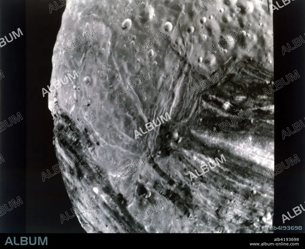
Miranda, one of the moons of Uranus, seen from Voyager 2, 24 January 1986. Creator: NASA.
| Teilen |
|---|
 Pinterest Pinterest |
 Twitter Twitter |
 Facebook Facebook |
 Link kopieren Link kopieren |
 Email Email |
|
Zu einem anderen Lightbox hinzufügen |
|
Zu einem anderen Lightbox hinzufügen |


Haben Sie bereits ein Konto? Anmelden
Sie haben kein Konto? Registrieren
Dieses Bild kaufen.
Nutzung auswählen:

Titel: Miranda, one of the moons of Uranus, seen from Voyager 2, 24 January 1986. Creator: NASA.
Untertitel: Siehe automatische Übersetzung
Miranda, one of the moons of Uranus, seen from Voyager 2, 24 January 1986. High-resolution image of Miranda, also designated Uranus V, the smallest and innermost of Uranus' five moons, taken from the Voyager unmanned spacecraft from a distance of approximately 31,000 kilometers (19,000 miles), shortly before the spacecraft's closest approach to the Uranian moon. The high resolution of 600 meters (2,000 feet) reveals fractures, grooves and craters, as well as features of different albedos (reflectancea). This view encompasses areas of older, heavily cratered terrain with a wide variety of forms. The grooves and troughs reach depths of a few kilometers (or miles) and expose materials of different albedos. The great variety of directions of fractures and troughs, and the different densities of impact craters on them, signify a long, complex geologic evolution of this satellite.
Miranda, one of the moons of Uranus, seen from Voyager 2, 24 January 1986. High-resolution image of Miranda, also designated Uranus V, the smallest and innermost of Uranus' five moons, taken from the Voyager unmanned spacecraft from a distance of approximately 31,000 kilometers (19,000 miles), shortly before the spacecraft's closest approach to the Uranian moon. The high resolution of 600 meters (2,000 feet) reveals fractures, grooves and craters, as well as features of different albedos (reflectancea). This view encompasses areas of older, heavily cratered terrain with a wide variety of forms. The grooves and troughs reach depths of a few kilometers (or miles) and expose materials of different albedos. The great variety of directions of fractures and troughs, and the different densities of impact craters on them, signify a long, complex geologic evolution of this satellite.
Bildnachweis: Album / Heritage Images / Heritage Space
Freigaben (Releases): ? Modellfreigabe: Nein - ? Eigentumsfreigabe: Nein
Rechtefragen?
Rechtefragen?
Bildgröße: 5301 × 4044 px | 61.3 MB
Druckgröße: 44.9 × 34.2 cm | 2087.0 × 1592.1 in (300 dpi)
Schlüsselwörter: 1980ER JAHRE • 80ER JAHRE • 80ER • ACHTZIGER JAHRE • ASTRONOMIE • GEOGRAFIE • GEOGRAPHIE • GEOLOGIE • KRATER (GEOLOGIE) • MOND • MONOCHROM • MONOCHROMIE • NASA • PLANET ALLE • PLANET • RAUMFAHRT • SCHWARZ UND WEISS • SCHWARZ-WEISS • SCHWARZWEISS • SONNENSYSTEM • UNIVERSUM (WELTALL) • WELTRAUM • WISSENSCH.: ASTRONOMIE
