alb5411190
Guillaume Delisle, Eastern Roman Empire Map, 400 AD
| Teilen |
|---|
 Pinterest Pinterest |
 Twitter Twitter |
 Facebook Facebook |
 Link kopieren Link kopieren |
 Email Email |
|
Zu einem anderen Lightbox hinzufügen |
|
Zu einem anderen Lightbox hinzufügen |


Haben Sie bereits ein Konto? Anmelden
Sie haben kein Konto? Registrieren
Dieses Bild kaufen

Titel:
Guillaume Delisle, Eastern Roman Empire Map, 400 AD
Untertitel:
Siehe automatische Übersetzung
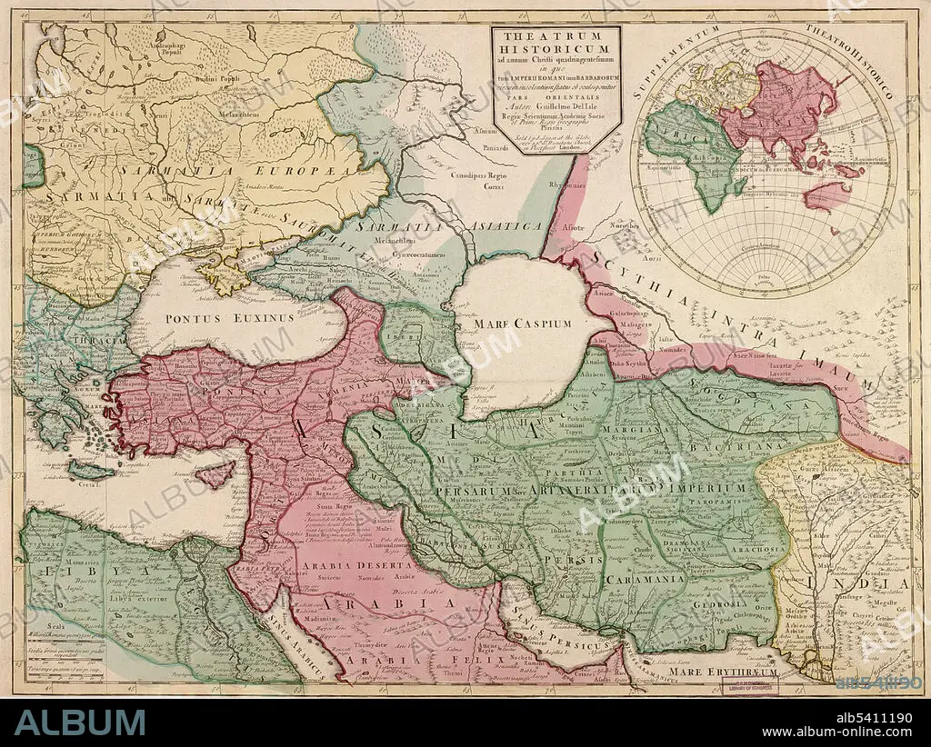
Theatrum historicum ad annum Christi quadringentesimum: in quo tum Imperii Romani tum Barbarorum circum incolentium status ob oculos ponitur pars orientalis. Inset map: Supplentum Theatro Historico, showing eastern hemisphere. Shows the eastern Roman Empire in 400 AD with boundaries, forests, settlements. Covers the Middle East from Libya and Greece to the Indus River. Guillaume Delisle (February 28, 1675, January 25, 1726) was a French cartographer known for his popular and accurate maps of Europe and the newly explored Americas. Like many cartographers of his day, Delisle did not travel with the explorers. He drew maps mostly in his office, relying on a variety of data. The quality of his maps depended on a solid network to provide him first-hand information. He also kept current with recent discoveries, especially in astronomy and measurement. When he could not confirm the accuracy of a source, he would indicate it clearly on his maps.
Bildnachweis:
Album / LOC/Geography and Map Division/Science Source
Freigaben (Releases):
Model: Nein - Eigentum: Nein
Rechtefragen?
Rechtefragen?
Bildgröße:
4350 x 3268 px | 40.7 MB
Druckgröße:
36.8 x 27.7 cm | 14.5 x 10.9 in (300 dpi)
Schlüsselwörter:
5. JAHRHUNDERT • 5. JH. • BERÜHMT • BERÜHMTE PERSÖNLICHKEIT • GEOGRAFIE • GEOGRAPHIE • GREECE • GRIECHENLAND • ILLUSTRATION • ILLUSTRATIONS • KARTHOGRAFIE • KARTOGRAFIE (KARTE) • KARTOGRAPHIE • NOTABEL • ORIENT • OST • OSTEN • PROMINENZ • ROM • WISSENSCH.: KARTOGRAPHIE
