alb5411517
Arab World Map
| Teilen |
|---|
 Pinterest Pinterest |
 Twitter Twitter |
 Facebook Facebook |
 Link kopieren Link kopieren |
 Email Email |
|
Zu einem anderen Lightbox hinzufügen |
|
Zu einem anderen Lightbox hinzufügen |


Haben Sie bereits ein Konto? Anmelden
Sie haben kein Konto? Registrieren
Dieses Bild kaufen.
Nutzung auswählen:

Titel: Arab World Map
Untertitel: Siehe automatische Übersetzung
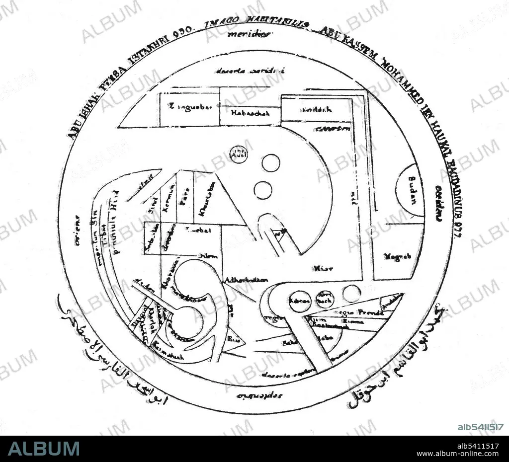
After its beginnings in the 8th century based on Hellenistic geography, Islamic geography was patronized by the Abbasid caliphs of Baghdad. Various Islamic scholars contributed to its development, and the most notable include Al-Khwarizmi, Abu Zayd al-Balkhi (founder of the Balkhi school), and Abu Rayhan Biruni. Islamic cartographers inherited Ptolemy's Almagest and Geography in the 9th century. These works stimulated an interest in geography but were not slavishly followed. Instead, Arabian and Persian cartography followed Al-Khwarizmi in adopting a rectangular projection, shifting Ptolemy's Prime Meridian several degrees eastward, and modifying many of Ptolemy's geographical coordinates. Having received Greek writings directly and without Latin intermediation, Arabian and Persian geographers made no use of European-style T-O maps. No artist credited, undated.
After its beginnings in the 8th century based on Hellenistic geography, Islamic geography was patronized by the Abbasid caliphs of Baghdad. Various Islamic scholars contributed to its development, and the most notable include Al-Khwarizmi, Abu Zayd al-Balkhi (founder of the Balkhi school), and Abu Rayhan Biruni. Islamic cartographers inherited Ptolemy's Almagest and Geography in the 9th century. These works stimulated an interest in geography but were not slavishly followed. Instead, Arabian and Persian cartography followed Al-Khwarizmi in adopting a rectangular projection, shifting Ptolemy's Prime Meridian several degrees eastward, and modifying many of Ptolemy's geographical coordinates. Having received Greek writings directly and without Latin intermediation, Arabian and Persian geographers made no use of European-style T-O maps. No artist credited, undated.
Bildnachweis: Album / Science Source
Freigaben (Releases): ? Modellfreigabe: Nein - ? Eigentumsfreigabe: Nein
Rechtefragen?
Rechtefragen?
Bildgröße: 4050 × 3468 px | 40.2 MB
Druckgröße: 34.3 × 29.4 cm | 1594.5 × 1365.4 in (300 dpi)
Schlüsselwörter: ARABISCH • BERÜHMT • BERÜHMTE PERSÖNLICHKEIT • GEOGRAFIE • GEOGRAPHIE • ILLUSTRATION • ILLUSTRATIONS • ISLAMISCH • KARTHOGRAFIE • KARTOGRAFIE (KARTE) • KARTOGRAPHIE • MOSLEM (MUSLIM) • NOTABEL • OEKUMENE • PROMINENZ • WELT • WISSENSCH.: KARTOGRAPHIE • ÖKUMENE
