alb4553190
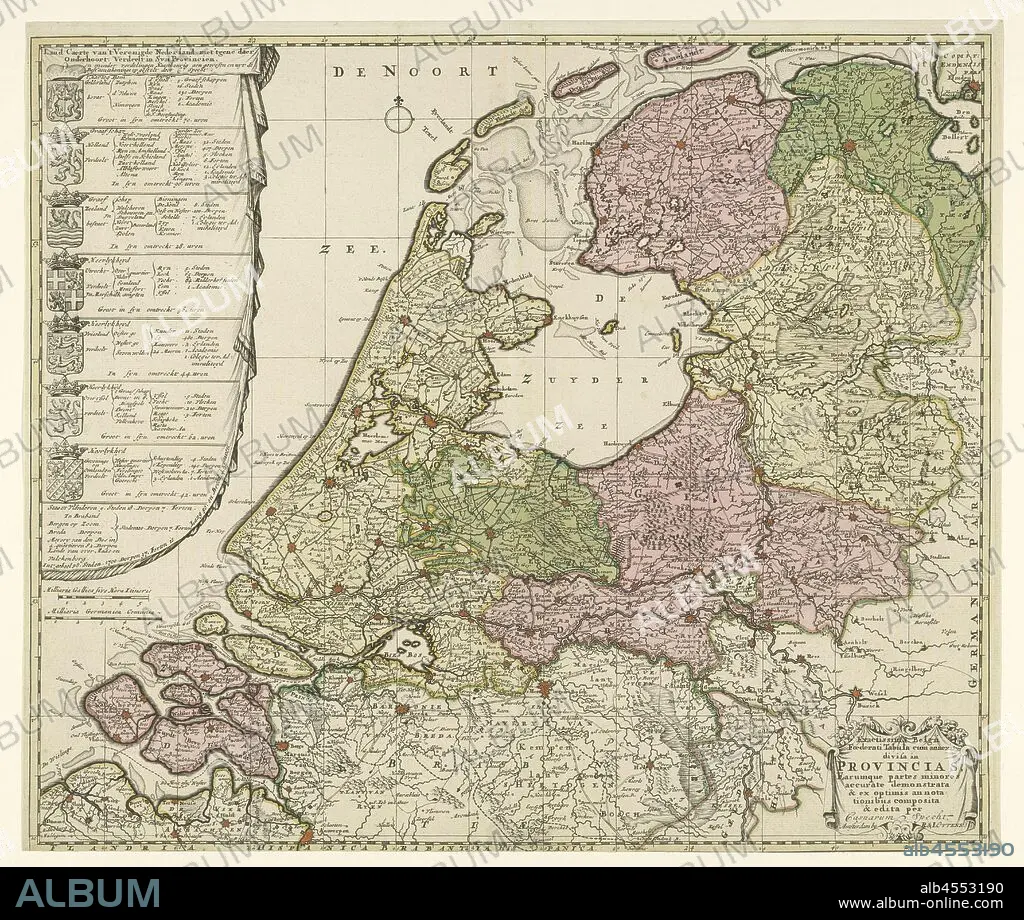
Map of the Republic of the Seven United Netherlands, the Caerte Country of the United Netherlands, with the rest of the subject, divided into syn Provincia / Exactissima Belgium Foederati Tabula cum annexis divisa in Provincias .., Map of the Republic with on the left the arms of the seven provinces with per province a subdivision into regions, numbers of cities, villages, vlecken, lands of the knights, cities, academies and colleges of Admiralty. Flanders has been added to the description, but without a weapon. Bottom right a cartouche with the title in Latin. The seven provinces are colored differently, the other areas are left uncoloured, maps of separate countries or regions, coat of arms (as symbol of the state, etc.) (province, provincial), Netherlands, Republic of the Seven United Netherlands, Caspar Specht (possibly), 1702 and/or 1726 - 1750, paper, engraving, h 510 mm × w 600 mm.
| Teilen |
|---|
 Pinterest Pinterest |
 Twitter Twitter |
 Facebook Facebook |
 Link kopieren Link kopieren |
 Email Email |
|
Zu einem anderen Lightbox hinzufügen |
|
Zu einem anderen Lightbox hinzufügen |


Haben Sie bereits ein Konto? Anmelden
Sie haben kein Konto? Registrieren
Dieses Bild kaufen.
Nutzung auswählen:

Untertitel:
Siehe automatische Übersetzung
Map of the Republic of the Seven United Netherlands, the Caerte Country of the United Netherlands, with the rest of the subject, divided into syn Provincia / Exactissima Belgium Foederati Tabula cum annexis divisa in Provincias .., Map of the Republic with on the left the arms of the seven provinces with per province a subdivision into regions, numbers of cities, villages, vlecken, lands of the knights, cities, academies and colleges of Admiralty. Flanders has been added to the description, but without a weapon. Bottom right a cartouche with the title in Latin. The seven provinces are colored differently, the other areas are left uncoloured, maps of separate countries or regions, coat of arms (as symbol of the state, etc.) (province, provincial), Netherlands, Republic of the Seven United Netherlands, Caspar Specht (possibly), 1702 and/or 1726 - 1750, paper, engraving, h 510 mm × w 600 mm
Bildnachweis:
Album / quintlox
Freigaben (Releases):
Bildgröße:
5881 x 4979 px | 83.8 MB
Druckgröße:
49.8 x 42.2 cm | 19.6 x 16.6 in (300 dpi)
Schlüsselwörter:
DORF • FREIMAURER: SYMBOLE • GENTLEMAN • GRAVUR • HOCHSCHULEN • KARTE (KARTHOGRAFIE) • KARTEN • KARTHOGRAPHIE • LANDKARTE • MANTEL • PALETOT • PAPIER • PLAN (KARTOGRAPHIE) • PROVINZ • PUEBLO • REGIONEN • REPUBLIK • RITTER • STICH (KUNST) • SYMBOL • WAFFE • WAFFEN
