alb3818051
Planisphere Coeleste, Star Map, 1680
| Teilen |
|---|
 Pinterest Pinterest |
 Twitter Twitter |
 Facebook Facebook |
 Link kopieren Link kopieren |
 Email Email |
|
Zu einem anderen Lightbox hinzufügen |
|
Zu einem anderen Lightbox hinzufügen |


Haben Sie bereits ein Konto? Anmelden
Sie haben kein Konto? Registrieren
Dieses Bild kaufen.
Nutzung auswählen:

Titel: Planisphere Coeleste, Star Map, 1680
Untertitel: Siehe automatische Übersetzung
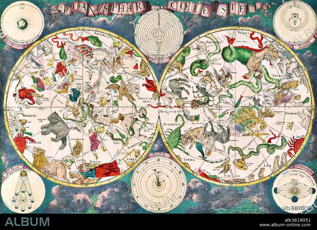
Planisphaeri coeleste, 1680, a celestial planisphere featuring the constellations of the northern and southern hemispheres with traditional representations of the signs of the Zodiac and constellations, including Draco, Serpens and Hydra. Astronomy and celestial star chart map by the Dutch cartographer family Frederik de Wit. A star chart or star map is a map of the night sky. Astronomers divide these into grids to use them more easily. They are used to identify and locate astronomical objects such as stars, constellations and galaxies. They have been used for human navigation since time immemorial. A planisphere is a type of star chart. The Atlas Coelestis is a star atlas published posthumously in 1729, based on observations made by the First Astronomer Royal, John Flamsteed.
Planisphaeri coeleste, 1680, a celestial planisphere featuring the constellations of the northern and southern hemispheres with traditional representations of the signs of the Zodiac and constellations, including Draco, Serpens and Hydra. Astronomy and celestial star chart map by the Dutch cartographer family Frederik de Wit. A star chart or star map is a map of the night sky. Astronomers divide these into grids to use them more easily. They are used to identify and locate astronomical objects such as stars, constellations and galaxies. They have been used for human navigation since time immemorial. A planisphere is a type of star chart. The Atlas Coelestis is a star atlas published posthumously in 1729, based on observations made by the First Astronomer Royal, John Flamsteed.
Bildnachweis: Album / Science Source / New York Public Library
Freigaben (Releases): ? Modellfreigabe: Nein - ? Eigentumsfreigabe: Nein
Rechtefragen?
Rechtefragen?
Bildgröße: 4200 × 2836 px | 34.1 MB
Druckgröße: 35.6 × 24.0 cm | 1653.5 × 1116.5 in (300 dpi)
Schlüsselwörter: ASTROLOGIE • ASTRONOMIE • BERÜHMT • BERÜHMTE PERSÖNLICHKEIT • DRACHEN (STERNBILD) • FISCHE (STERNZEICHEN) • KREBS • NOTABEL • PROMINENZ • SCHLANGE (STERNBILD) • STEINBOCK (STERNZEICHEN) • STERNZEICHEN • TIERKREIS • WIDDER (STERNZEICHEN) • WISSENSCH.: ASTRONOMIE
