alb1647120
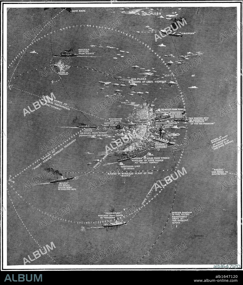
Chart of the RMS Titanic wreck site showing ships within call by wireless at the time of the collision.
| Teilen |
|---|
 Pinterest Pinterest |
 Twitter Twitter |
 Facebook Facebook |
 Link kopieren Link kopieren |
 Email Email |
|
Zu einem anderen Lightbox hinzufügen |
|
Zu einem anderen Lightbox hinzufügen |


Haben Sie bereits ein Konto? Anmelden
Sie haben kein Konto? Registrieren
Dieses Bild kaufen

Untertitel:
Siehe automatische Übersetzung
Chart of the RMS Titanic wreck site showing ships within call by wireless at the time of the collision
Bildnachweis:
Album / Universal Images Group / Universal History Archive
Freigaben (Releases):
Model: Nein - Eigentum: Nein
Rechtefragen?
Rechtefragen?
Bildgröße:
4129 x 4606 px | 54.4 MB
Druckgröße:
35.0 x 39.0 cm | 13.8 x 15.4 in (300 dpi)
Schlüsselwörter:
BRITISCHE • DACHWOHNUNG • EISBERG • ENGLISCH • FOTOGRAFIE • GESTIRN • KARTE (KARTHOGRAFIE) • KARTE • KARTEN • KARTHOGRAPHIE • KATASTROPHE • KEN • LANDKARTE • LINIE • MEER • MEERE • MOMENTAUFNAHME • OZEAN • PLAN (KARTOGRAPHIE) • RADIO • SCHIFF: SCHIFFBRUCH • SCHIFFBRUCH • SCHWARZ UND WEISS • SCHWARZ-WEIß • SCHWARZWEISS • SEA • SEENOT • SEESTUECK (GEMAELDE) • STERN • TITANIC • UNGLUECK • UNGLÜCK • UNGLÜCKE • UNHEIL • WEISS (FARBE) • WEISS • ZEILE • ZUSAMMENSTOSS
