alb8371502
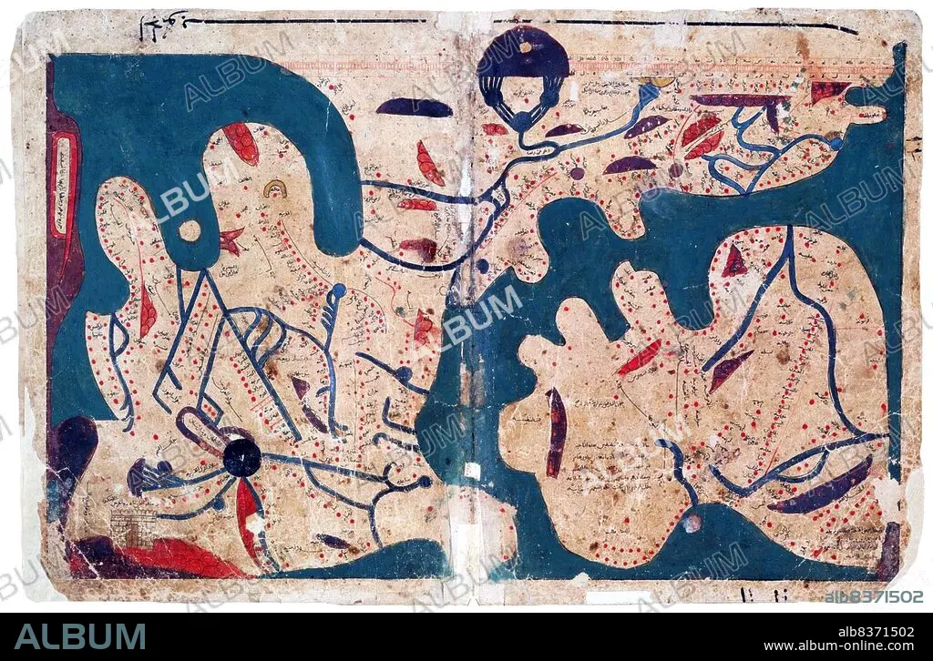
Egypt: Map of the world (south to the top), said to be the oldest rectangular map of the world, Kitab Ghara'ib al-funun wa-mulah al-'uyun< / i> ('The Book of Curiosities of the Sciences and Marvels for the Eyes'),12th-13th Centuries
| Teilen |
|---|
 Pinterest Pinterest |
 Twitter Twitter |
 Facebook Facebook |
 Link kopieren Link kopieren |
 Email Email |
|
Zu einem anderen Lightbox hinzufügen |
|
Zu einem anderen Lightbox hinzufügen |


Haben Sie bereits ein Konto? Anmelden
Sie haben kein Konto? Registrieren
Dieses Bild kaufen

Titel:
Egypt: Map of the world (south to the top), said to be the oldest rectangular map of the world, Kitab Ghara'ib al-funun wa-mulah al-'uyun< / i> ('The Book of Curiosities of the Sciences and Marvels for the Eyes'),12th-13th Centuries
Untertitel:
Siehe automatische Übersetzung
Composed in Egypt in the first half of the 11th century, the 'Book of Curiosities' is a 12th/13th century cosmographical manuscript contains highly unique celestial and terrestrial maps, including the first known rectangular map of the world produced before the renaissance.
. The geographical references are based largely on the first century work of Ptolemy but the manuscript contains previously unknown distinct cartographic features.
. The geographical references are based largely on the first century work of Ptolemy but the manuscript contains previously unknown distinct cartographic features.
Bildnachweis:
Album / Universal Images Group / Pictures From History
Freigaben (Releases):
Model: Nein - Eigentum: Nein
Rechtefragen?
Rechtefragen?
Bildgröße:
5100 x 3351 px | 48.9 MB
Druckgröße:
43.2 x 28.4 cm | 17.0 x 11.2 in (300 dpi)
Schlüsselwörter:
12. JAHRHUNDERT • 12. JH. • 13. JAHRHUNDERT • 13. JH. • AEGYPTEN • AEGYPTISCH • ARABISCH • EGYPTISCH • ISLAM • KARTE (KARTHOGRAFIE) • KARTE • KARTEN • KARTHOGRAFIE • KARTHOGRAPHIE • KARTOGRAFIE (KARTE) • KARTOGRAPHIE • KUNST • LANDKARTE • MOHAMMEDANER • MOHAMMEDANERIN • MOSLEM • MOSLEMIN • MUSLIM • MUSLIMIN • ORIENTE MEDIO • PLAN (KARTOGRAPHIE) • WELTKARTE • WISSENSCH.: KARTOGRAPHIE • WISSENSCHAFT • WISSENSCHAFTEN • ÄGYPTEN
