alb9882067
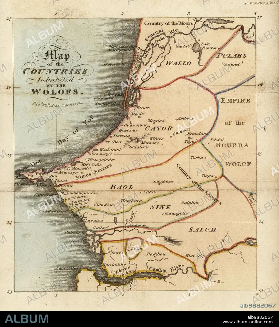
Map of the Jolof or Wolof Empire on the west coast of Africa. Shows Waalo, Kayor, Baol, Sine and Saloum areas, the Senegal and Gambia rivers, and the slave island of Goree. Map of the countres of inhabited by the Wolofs. After Rene Claude Geoffroy de Villeneuves LAfrique, Paris, 1814. Handcoloured stipple copperplate engraving from Frederic Shoberls The World in Miniature: Africa, A description of the manners and customs Moors of the Sahara and of the Negro Nations, R. Ackermann, England, 1821.
| Teilen |
|---|
 Pinterest Pinterest |
 Twitter Twitter |
 Facebook Facebook |
 Link kopieren Link kopieren |
 Email Email |
|
Zu einem anderen Lightbox hinzufügen |
|
Zu einem anderen Lightbox hinzufügen |


Haben Sie bereits ein Konto? Anmelden
Sie haben kein Konto? Registrieren
Dieses Bild kaufen.
Nutzung auswählen:

Untertitel: Siehe automatische Übersetzung
Map of the Jolof or Wolof Empire on the west coast of Africa. Shows Waalo, Kayor, Baol, Sine and Saloum areas, the Senegal and Gambia rivers, and the slave island of Goree. Map of the countres of inhabited by the Wolofs. After Rene Claude Geoffroy de Villeneuves LAfrique, Paris, 1814. Handcoloured stipple copperplate engraving from Frederic Shoberls The World in Miniature: Africa, A description of the manners and customs Moors of the Sahara and of the Negro Nations, R. Ackermann, England, 1821.
Map of the Jolof or Wolof Empire on the west coast of Africa. Shows Waalo, Kayor, Baol, Sine and Saloum areas, the Senegal and Gambia rivers, and the slave island of Goree. Map of the countres of inhabited by the Wolofs. After Rene Claude Geoffroy de Villeneuves LAfrique, Paris, 1814. Handcoloured stipple copperplate engraving from Frederic Shoberls The World in Miniature: Africa, A description of the manners and customs Moors of the Sahara and of the Negro Nations, R. Ackermann, England, 1821.
Bildnachweis: Album / Florilegius
Freigaben (Releases): ? Modellfreigabe: Nein - ? Eigentumsfreigabe: Nein
Rechtefragen?
Rechtefragen?
Bildgröße: 5707 × 6355 px | 103.8 MB
Druckgröße: 48.3 × 53.8 cm | 2246.9 × 2502.0 in (300 dpi)
Schlüsselwörter: AFRIKA • ERKUNDUNG • KARTE (KARTHOGRAFIE) • KARTEN • KARTHOGRAPHIE • LANDKARTE • MENSCHENHANDEL • PLAN (KARTOGRAPHIE) • REISE • REISENDER • SKLAVENHANDEL • SKLAVEREI • WALZ
