alb4492589
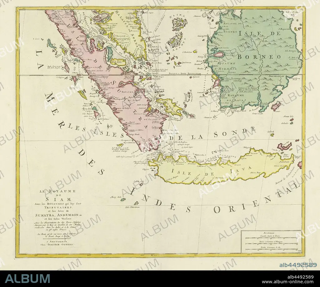
Map of the Kingdom of Siam (lower half), Le Royaume de Siam, avec les royaumes qui lui sont tributaires and les iles de Sumatra, Andemaon, etc, et les iles Voisines (title on object), Map of the Kingdom of Siam (Kingdom of Ayutthaya) and its vassal states. Different areas colored differently. Depicted are the islands of Sumatra, Java and Borneo and part of Malacca. A dotted line and a normal line indicate the route of the Jesuit cartographers, sent by the king, through the area, from top to center. Bottom right scale in French, German and nautical miles. Bottom part of a map of the entire kingdom, maps of separate countries or regions, Indonesia, Sumatra, Java, Borneo, Malacca, Joachim Ottens (mentioned on object), Amsterdam, 1700 - 1750, paper, engraving, h 479 mm × w 554 mm.
| Teilen |
|---|
 Pinterest Pinterest |
 Twitter Twitter |
 Facebook Facebook |
 Link kopieren Link kopieren |
 Email Email |
|
Zu einem anderen Lightbox hinzufügen |
|
Zu einem anderen Lightbox hinzufügen |


Haben Sie bereits ein Konto? Anmelden
Sie haben kein Konto? Registrieren
Dieses Bild kaufen.
Nutzung auswählen:

Untertitel:
Siehe automatische Übersetzung
Map of the Kingdom of Siam (lower half), Le Royaume de Siam, avec les royaumes qui lui sont tributaires and les iles de Sumatra, Andemaon, etc, et les iles Voisines (title on object), Map of the Kingdom of Siam (Kingdom of Ayutthaya) and its vassal states. Different areas colored differently. Depicted are the islands of Sumatra, Java and Borneo and part of Malacca. A dotted line and a normal line indicate the route of the Jesuit cartographers, sent by the king, through the area, from top to center. Bottom right scale in French, German and nautical miles. Bottom part of a map of the entire kingdom, maps of separate countries or regions, Indonesia, Sumatra, Java, Borneo, Malacca, Joachim Ottens (mentioned on object), Amsterdam, 1700 - 1750, paper, engraving, h 479 mm × w 554 mm
Bildnachweis:
Album / quintlox
Freigaben (Releases):
Bildgröße:
5729 x 4838 px | 79.3 MB
Druckgröße:
48.5 x 41.0 cm | 19.1 x 16.1 in (300 dpi)
Schlüsselwörter:
AMSTERDAM • BORNEO • DEUTSCH • FRANZOESISCH • FRANZOSE • FRANZÖSIN • GRAVUR • INSEL • KARTE (KARTHOGRAFIE) • KARTEN • KARTHOGRAPHIE • KOENIG • KÖNIG • KÖNIGREICH • LANDKARTE • OBJEKT • PAPIER • PLAN (KARTOGRAPHIE) • REGIONEN • STICH (KUNST) • VOLKSKUNST: INDONESISCH
