alb3839823
Mississippi Delta
| Teilen |
|---|
 Pinterest Pinterest |
 Twitter Twitter |
 Facebook Facebook |
 Link kopieren Link kopieren |
 Email Email |
|
Zu einem anderen Lightbox hinzufügen |
|
Zu einem anderen Lightbox hinzufügen |


Haben Sie bereits ein Konto? Anmelden
Sie haben kein Konto? Registrieren
Dieses Bild kaufen.
Nutzung auswählen:

Titel: Mississippi Delta
Untertitel: Siehe automatische Übersetzung
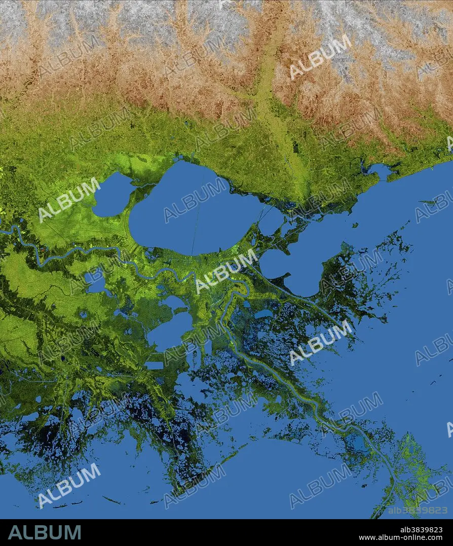
The geography of the New Orleans and Mississippi delta region is well shown in this radar image from the Shuttle Radar Topography Mission. In this image, bright areas show regions of high radar reflectivity, such as from urban areas, and elevations have been coded in color using height data also from the mission. Dark green colors indicate low elevations, rising through yellow and tan, to white at the highest elevations.....New Orleans is situated along the southern shore of Lake Pontchartrain, the large, roughly circular lake near the center of the image. The line spanning the lake is the Lake Pontchartrain Causeway, the world's longest over water highway bridge. Major portions of the city of New Orleans are below sea level, and although it is protected by levees and sea walls, flooding during storm surges associated with major hurricanes is a significant concern.....Data used in this image were acquired by the Shuttle Radar Topography Mission aboard the Space Shuttle Endeavour, launched on Feb. 11, 2000.
The geography of the New Orleans and Mississippi delta region is well shown in this radar image from the Shuttle Radar Topography Mission. In this image, bright areas show regions of high radar reflectivity, such as from urban areas, and elevations have been coded in color using height data also from the mission. Dark green colors indicate low elevations, rising through yellow and tan, to white at the highest elevations.....New Orleans is situated along the southern shore of Lake Pontchartrain, the large, roughly circular lake near the center of the image. The line spanning the lake is the Lake Pontchartrain Causeway, the world's longest over water highway bridge. Major portions of the city of New Orleans are below sea level, and although it is protected by levees and sea walls, flooding during storm surges associated with major hurricanes is a significant concern.....Data used in this image were acquired by the Shuttle Radar Topography Mission aboard the Space Shuttle Endeavour, launched on Feb. 11, 2000.
Kategorie: WISSENSCHAFT
Bildnachweis: Album / Science Source / NASA/JPL/NGA
Freigaben (Releases): ? Modellfreigabe: Nein - ? Eigentumsfreigabe: Nein
Rechtefragen?
Rechtefragen?
Bildgröße: 1800 × 2061 px | 10.6 MB
Druckgröße: 15.2 × 17.4 cm | 708.7 × 811.4 in (300 dpi)
Schlüsselwörter: GEOGRAFIE • GEOGRAPHIE • GEOLOGIE • TOPOGRAPHIE • WISSENSCHAFT
