alb9871596
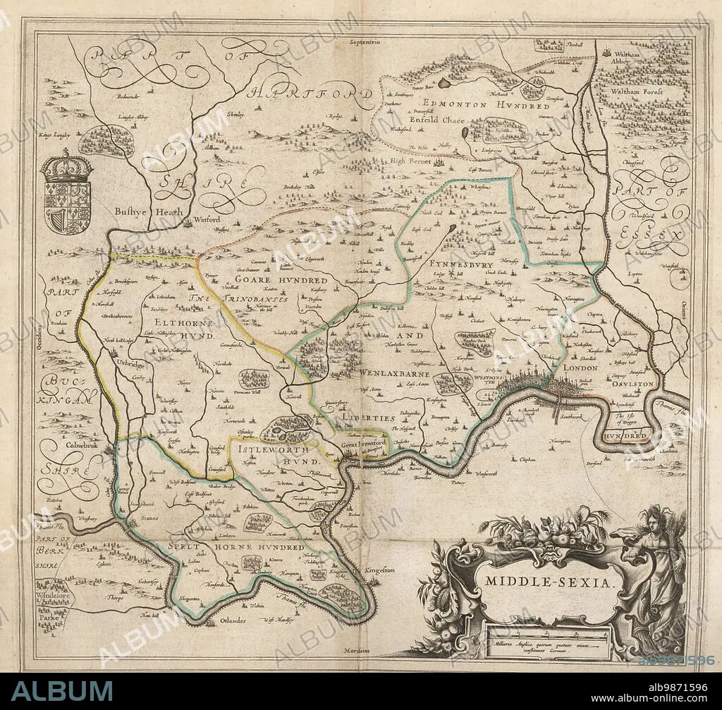
Map of the city of London and county of Middlesex, circa 1600. London shown as clutch of churches, surrounded by parishes Kensington, Chelsey, St. Gylles, Lambeth, Southwork, Hampton Court, on the River Thames, Hyde Park and Marybon Park. With title Middle-Sexia in cartouche and coat of arms. Handcoloured copperplate engraving by Johannes Blaeu from Geographiae Volumen Quintum quo Angliae, county atlas of England and Wales, Amsterdam, 1662.
| Teilen |
|---|
 Pinterest Pinterest |
 Twitter Twitter |
 Facebook Facebook |
 Link kopieren Link kopieren |
 Email Email |
|
Zu einem anderen Lightbox hinzufügen |
|
Zu einem anderen Lightbox hinzufügen |


Haben Sie bereits ein Konto? Anmelden
Sie haben kein Konto? Registrieren
Dieses Bild kaufen.
Nutzung auswählen:

Untertitel:
Siehe automatische Übersetzung
Map of the city of London and county of Middlesex, circa 1600. London shown as clutch of churches, surrounded by parishes Kensington, Chelsey, St. Gylles, Lambeth, Southwork, Hampton Court, on the River Thames, Hyde Park and Marybon Park. With title Middle-Sexia in cartouche and coat of arms. Handcoloured copperplate engraving by Johannes Blaeu from Geographiae Volumen Quintum quo Angliae, county atlas of England and Wales, Amsterdam, 1662.
Bildnachweis:
Album / Florilegius
Freigaben (Releases):
Bildgröße:
5081 x 4740 px | 68.9 MB
Druckgröße:
43.0 x 40.1 cm | 16.9 x 15.8 in (300 dpi)
Schlüsselwörter:
AMSTERDAM • ECCLESIA • FLUSS THEMSE • GEOGRAFIE • GEOGRAPHIE • GESCHICHTE • HOLLAENDISCH • INNENRAEUME: KIRCHEN • KARTE (KARTHOGRAFIE) • KARTE • KARTEN • KARTHOGRAPHIE • KIRCHE • KIRCHEN • KLEIDUNG, HOLLAENDISCH • LANDKARTE • LONDON • PLAN (KARTOGRAPHIE) • STADT • STÄDTE • THEMSE, FLUSS • TOPOGRAPHIE • ZEITGESCHICHTE
