alb3827738
Tsunami Inundation, Thailand
| Teilen |
|---|
 Pinterest Pinterest |
 Twitter Twitter |
 Facebook Facebook |
 Link kopieren Link kopieren |
 Email Email |
|
Zu einem anderen Lightbox hinzufügen |
|
Zu einem anderen Lightbox hinzufügen |


Haben Sie bereits ein Konto? Anmelden
Sie haben kein Konto? Registrieren
Dieses Bild kaufen.
Nutzung auswählen:

Titel:
Tsunami Inundation, Thailand
Untertitel:
Siehe automatische Übersetzung
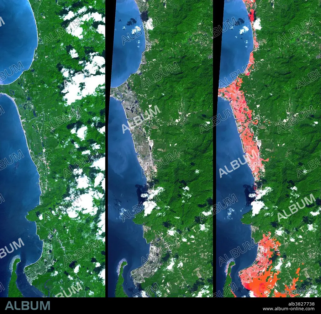
The Indian Ocean coastline north of Phuket, Thailand is a major tourist destination that was in the path of the tsunami produced by a giant offshore earthquake on December 26, 2004. This disaster resulted in a heavy loss of life. These simulated natural color ASTER (Advanced Spaceborne Thermal Emission and Reflection Radiometer) images show a 27 kilometer (17 mile) long stretch of coast 80 kilometers (50 miles) north of the Phuket airport in the Khao Lak area on December 31 (middle) and also two years earlier (left). The changes along the coast are obvious (changing from green to grey) where the vegetation was stripped away by the tsunami. The image on the right is a copy of the later ASTER scene but it includes highlighting in red for areas that have elevations within 10 meters (33 feet) of sea level. This elevation information was supplied by the Shuttle Radar Topography Mission (SRTM). The red areas appear to include most of the tsunami inundated areas. The geographic correspondence
Kategorie:
WISSENSCHAFT
Bildnachweis:
Album / Science Source / NASA/GSFC/METI/ERSDAC/JAROS, and U.S./Japan ASTER Science Team
Freigaben (Releases):
Bildgröße:
1987 x 1840 px | 10.5 MB
Druckgröße:
16.8 x 15.6 cm | 6.6 x 6.1 in (300 dpi)
Schlüsselwörter:
ASIEN • ASIEN, KONTINENT • GEOLOGIE • KONTINENT, ASIEN • KUESTE • KÜSTE • MARITIM • TOPOGRAPHIE • TRAGOEDIE • TRAGÖDIE • TRAUERSPIEL • TSUNAMI • WISSENSCHAFT
