alb4859764
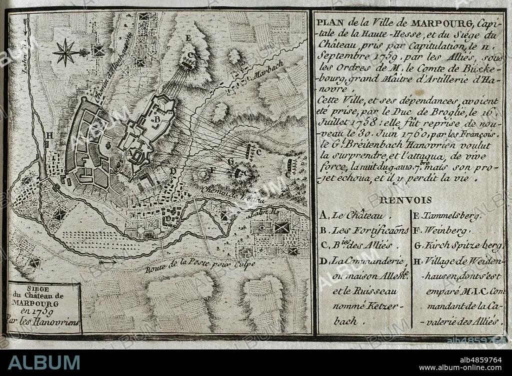
JEAN DE BEAURAIN (1696-1771). FRENCH GEOGRAPHER.. Seven Years War (1756-1763). Map of Marburg and siege of the castle, 1759. Taken by capitulation on 11 September 1759 by the Allied forces under the command of the Count of Buckeburg. Marburg had been captured by the Duke of Broglie on 16 July 1758, being seized again by the French on 30 June 1760. Published in 1765 by the cartographer Jean de Beaurain (1696-1771) as an illustration of his Great Map of Germany, with the events that took place during the Seven Years War. Etching and engraving. French edition, 1765. Military Historical Library of Barcelona (Biblioteca Histórico Militar de Barcelona). Catalonia. Spain.
| Share |
|---|
 Pinterest Pinterest |
 Twitter Twitter |
 Facebook Facebook |
 Copy link Copy link |
 Email Email |
|
Add to another lightbox |
|
Add to another lightbox |


Buy this image.
Select the use:

Caption:
Seven Years War (1756-1763). Map of Marburg and siege of the castle, 1759. Taken by capitulation on 11 September 1759 by the Allied forces under the command of the Count of Buckeburg. Marburg had been captured by the Duke of Broglie on 16 July 1758, being seized again by the French on 30 June 1760. Published in 1765 by the cartographer Jean de Beaurain (1696-1771) as an illustration of his Great Map of Germany, with the events that took place during the Seven Years War. Etching and engraving. French edition, 1765. Military Historical Library of Barcelona (Biblioteca Histórico Militar de Barcelona). Catalonia. Spain.
Location:
Historical Military Library of Barcelona. Catalonia. Spain.
Credit:
Album / Prisma
Releases:
Image size:
4687 x 3193 px | 42.8 MB
Print size:
39.7 x 27.0 cm | 15.6 x 10.6 in (300 dpi)
Keywords:
11 SEPTEMBER • 1758 • 1759 • 1760 • 1765 • 18 CENTURY • 18TH CENTURY • 18TH CENTURY, THE • 18TH CENTURY. • 18TH • 2001 SEPTEMBER 11 • 9-11 • 9/11 • ARMY, FRENCH • BASTION • BEAURAIN • BESIEGE • BROGLIE • BUCKEBURG • BULWARK • CAMP • CAPITULATION • CARTOGRAPHY • CASTILLO • CASTLE • CHATEAU • CITADEL • CITY WALLS • CITY • CONFLICT • CONFLICTS • COUNT OF BUCKEBURG • DEUTSCHLAND • DUKE OF BROGLIE • ENGRAVED • ENGRAVING (ARTWORK) • ENGRAVING • ENGRAVING. • ENGRAVINGS • ETCHING • EUROPA • EUROPE • EUROPEA • EUROPEAN • EUROPEANS • FORT • FORTIFICACION • FORTIFICATION • FORTITUDE • FORTRESS • FRENCH EDITION • GERMAN • GERMANS • GERMANY HISTORY • GERMANY • GREAT MAP OF GERMANY • GUERRA • HESSE • HISTORIA DE ALEMANIA • HISTORIA UNIVERSAL • HISTORIA • HISTORICAL MILITARY LIBRARY OF BARCELONA. CATALONIA. SPAIN. • HISTORY • HISTORY. • HUNDRED YEARS WAR • JEAN DE BEAURAIN (1696-1771). FRENCH GEOGRAPHER. • JEAN DE BEAURAIN • JULY 16 • MAP MAKING • MAP • MAPS • MARBURG • MODERN AGE • MODERN ERA • MODERN PERIOD • OLD MAP • PALACE • PLAN (CARTOGRAPHY) • PLAN • PLANE • PRINT • RAMPART • SEPT 11 • SEPTEMBER 11 ATTACKS • SEPTEMBER 11 • SEVEN YEARS WAR • SEVEN YEARS' WAR • SIEGE • SILESIAN WAR • SITE • STRENGTH • STRONGHOLD • SURRENDER • TOWN • URBE • VILLAGE • WALL • WAR • WAR, SEVEN YEARS • WAR, SILESIAN • WARFARE • WARS • XVIII CENTURY
