alb3831113
Tsunami Map, Honshu Earthquake, 1968
| Share |
|---|
 Pinterest Pinterest |
 Twitter Twitter |
 Facebook Facebook |
 Copy link Copy link |
 Email Email |
|
Add to another lightbox |
|
Add to another lightbox |


Buy this image.
Select the use:

Title:
Tsunami Map, Honshu Earthquake, 1968
Caption:
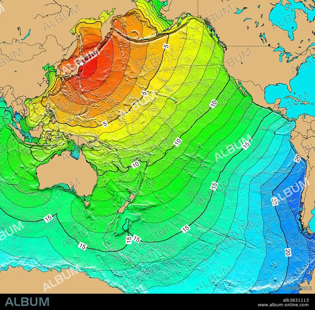
A magnitude 8.2 Mw earthquake on May 16, 1968 off the coast of Honshu Island caused destruction in Japan and generated a tsunami that was observed by tide gauges in Japan and throughout the Pacific Basin. As a result of the earthquake and tsunami, 52 people died and 329 people were injured; 676 homes were completely destroyed and 2,994 homes were partially destroyed; 13 homes burned down and 529 homes were flooded; 97 ships were washed away and 30 were sunk. In addition, roads, bridges and protective dikes were destroyed. Map generated using Tsunami Travel Time (TTT) software: calculates first-arrival travel times on a grid for a tsunami generated at an earthquake epicenter. Map contours: 1 hour intervals: red 1-4 hour arrival times, yellow: 5-6 hour arrival times, green: 7-14 hour arrival times, blue: 15-21 hour arrival times. Maps were generated from earthquake epicenters in the NGDC Global Historical Tsunami Database using NGDC 2 Minute Gridded Global Relief Data bathymetry. Maps do not provide the height or the strength of the wave, only the arrival times.
Category:
WEATHER • RESEARCH
Credit:
Album / NOAA/Science Source
Releases:
Image size:
3900 x 3632 px | 40.5 MB
Print size:
33.0 x 30.8 cm | 13.0 x 12.1 in (300 dpi)
Keywords:
1960S • 1968 • 2 MINUTE GRIDDED GLOBAL RELIEF DATA • 20 20TH XX XXTH TWENTIETH CENTURY • 20 XX TWENTIETH CENTURY • 20TH CENTURY • 20TH • 60 60'S DECADE SIXTY YEARS • 60 60'S DECADE YEARS SIXTY SIXTIES • 60'S • 60S • ARRIVAL TIME • BATHYMETRIC • BATHYMETRY • CELEBRITIES • CELEBRITY • CHART • CONTOUR • EARTH SCIENCE • EARTHQUAKE EPICENTER • EARTHQUAKE • EVENT • EVENTS • FAMOUS PEOPLE • FAMOUS • FLEET • GEOLOGIA • GEOLOGIC HAZARD • GEOLOGICAL • GEOLOGY • GEOPHYSICAL • GLOBAL HISTORICAL TSUNAMI DATABASE • HISTORIC • HISTORICAL • HISTORY • HONSHU ISLAND • HONSHÛ • HYDROGRAPHIC • HYDROGRAPHY • IMPORTANT • JAPAN • JAPANESE • MAP • MARINE • MAY 16 • MAY 16TH • NATIONAL CENTERS FOR ENVIRONMENTAL INFORMATION • NATIONAL GEOPHYSICAL DATA CENTER • NATIONAL OCEANIC AND ATMOSPHERIC ADMINISTRATION • NATURAL DISASTER • NAVY • NCEI • NGDC • NOAA • NOTABLE • OCEAN DEPTH • OCEAN • OCEANS • PACIFIC • PHENOMENA • PHENOMENON • RESEARCH • SEA • SEA. • SEAS • SEISMIC • SEISMOLOGICAL • SEISMOLOGY • SIXTIES • SIXTIES, THE • TECHNOLOGICAL • TECHNOLOGY • TRAVEL TIME • TSUNAMI TRAVEL TIME • TSUNAMI WAVES • TSUNAMI • TTT • TWENTIETH CENTURY • WEA • WEATHER • WEATHER: WEA • WELL-KNOWN • YEARS DECADE'S SIXTY SIXTIES 60 60 1960
