alb3547306
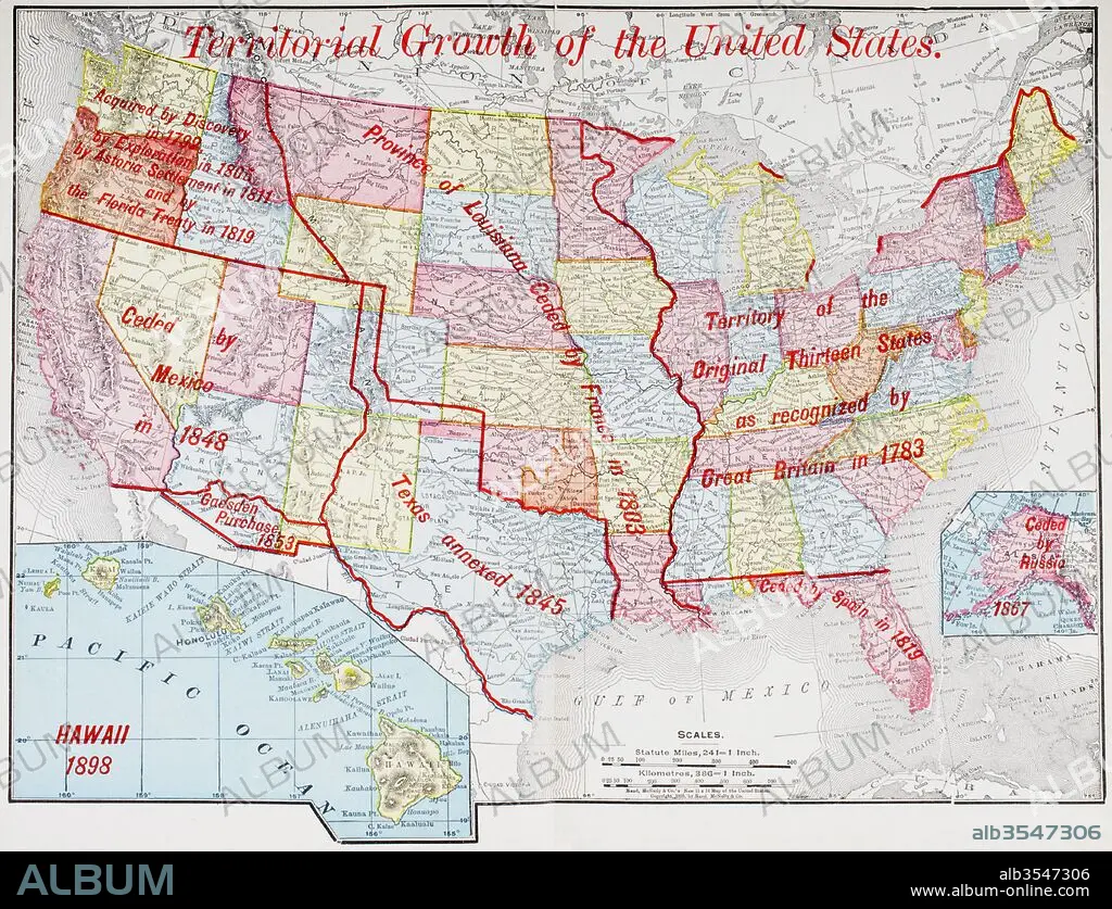
Map from 1898 showing the territorial growth of the United States of America
| Share |
|---|
 Pinterest Pinterest |
 Twitter Twitter |
 Facebook Facebook |
 Copy link Copy link |
 Email Email |
|
Add to another lightbox |
|
Add to another lightbox |


Buy this image.
Select the use:

Title: Map from 1898 showing the territorial growth of the United States of America
Caption: Map from 1898 showing the territorial growth of the United States of America. From The History of Our Country, published 1900
Credit: Album / Universal Images Group / Universal History Archive
Releases: ? Model Release: No - ? Property Release: No
Rights questions?
Rights questions?
Image size: 4783 × 3664 px | 50.1 MB
Print size: 40.5 × 31.0 cm | 1883.1 × 1442.5 in (300 dpi)
Keywords: 13 • 1898 • 19 CENTURY • 19TH CENTURY • 19TH CENTURY. • 19TH • 19TH-CENTURY • ACQUISITIONS • ALASKA • AMERICA • AMERICA. • AMERICAN • AMERICANS • AMERICAS • AMERICAS, THE • ANNEXATION • ANNEXES • BRITAIN • BRITISH • CENTURY • CESSION • CHART • CONQUESTS • COUNTRY • DANISH • DENMARK • EEUU • ENGLAND'S • ENGLAND • ENGLISH • ESPANA • EXPANSION • FRANCE • FRANCE. • GADSDEN • GEOGRAFIA • GEOGRAPHICAL • GEOGRAPHY • GREAT BRITAIN • GREAT-BRITAIN • GROWTH • HISTORIA UNIVERSAL • HISTORIA • HISTORICAL • HISTORY • HISTORY. • ILLUSTRATION • ILLUSTRATIONS • ILUSTRATION • INVENTIVE • KINGDOM • LA FRANCE • LOUISIANA • MAP • MAPS • MEXICAN • MEXICO • NINETEENTH CENTURY • NINETEENTH • ORIGINAL • PLAN (CARTOGRAPHY) • PURCHASE • PURCHASES • RUSIA • RUSSIA • RUSSIAN • SPAIN • SPANISH • STATE • STATES • TERRITORIAL • TERRITORY • TEXAS • THIRTEEN • TREATY • U S A • U. K. • U. S. A • U. S. A. • U. S. • UNITED KINGDOM • UNITED STATES AMERICA • UNITED STATES OF AMERICA • UNITED STATES • UNITED • US • US-AMERICAN • USA • USA. UNITED STATES • XIX CENTURY
