alb1655975
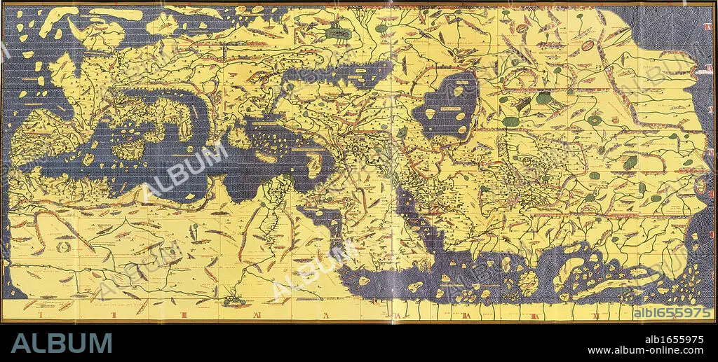
The 'Kitab Rudjdjar' or 'Tabula Rogeriana', an early world map the work of the Arab geographer Muhammad al-Idrisi (1100-1165) in 1154 for Roger II (1095-1154) King of Sicily from 1130. In this map, North is at the bottom.
| Share |
|---|
 Pinterest Pinterest |
 Twitter Twitter |
 Facebook Facebook |
 Copy link Copy link |
 Email Email |
|
Add to another lightbox |
|
Add to another lightbox |


Buy this image.
Select the use:

Caption:
The 'Kitab Rudjdjar' or 'Tabula Rogeriana', an early world map the work of the Arab geographer Muhammad al-Idrisi (1100-1165) in 1154 for Roger II (1095-1154) King of Sicily from 1130. In this map, North is at the bottom.
Category:
UIG HISTORY
Credit:
Album / Universal History Archive/Universal Images Group
Releases:
Image size:
6284 x 2850 px | 51.2 MB
Print size:
53.2 x 24.1 cm | 20.9 x 9.5 in (300 dpi)
Keywords:
1095-1154 • 1100-1165 • 1130 • 1154 • 12 CENTURY • 12TH CENTURY • 12TH • AL-IDRISI • ARAB • ARABE • ARABIAN • ARABIC • BACKSIDE • BOTTOM • BUTT • CARTOGRAPHY • CENTURY • EARLY • EXPLORATION • GEOGRAFIA • GEOGRAPHER • GEOGRAPHY • II • II. • KING • KITÁB • MAP MAKING • MAP • MAPS • MUHAMMAD • NORDEN • NORTH • PLAN (CARTOGRAPHY) • ROGER • ROGERIANA • RUDJDJAR • SICILY • TABULA • TWELFTH • UIG HISTORY • WORK • WORLD • XII CENTURY
