alb2602320
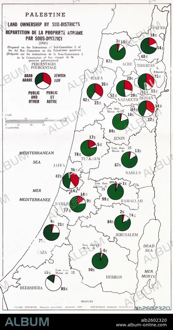
Map showing Palestine Land Ownership by Sub-District.
| Share |
|---|
 Pinterest Pinterest |
 Twitter Twitter |
 Facebook Facebook |
 Copy link Copy link |
 Email Email |
|
Add to another lightbox |
|
Add to another lightbox |


Buy this image.
Select the use:

Title:
Map showing Palestine Land Ownership by Sub-District.
Caption:
Map showing Palestine land ownership percentages by sub-district. Arab ownership is marked in green and Jewish ownership is makerd in red. Dated 1945.
Credit:
Album / Universal Images Group / Universal History Archive
Releases:
Model: No - Property: No
Rights questions?
Rights questions?
Image size:
2808 x 5100 px | 41.0 MB
Print size:
23.8 x 43.2 cm | 9.4 x 17.0 in (300 dpi)
Keywords:
1940 • 1940S • 20 20TH XX XXTH TWENTIETH CENTURY • 20 XX TWENTIETH CENTURY • 20TH CENTURY • 20TH • ARAB • ARABE • ARABIAN • ARABIC • DAVID • ISRAEL • JEW • JEWISH • JEWS • LAND • MAP • MAPS • OWNERSHIP • PALESTINAN • PALESTINE • PERCENTAGE • PLAN (CARTOGRAPHY) • PROPERTY • SUB-DISTRICT • TWENTIETH CENTURY
