alb4859776
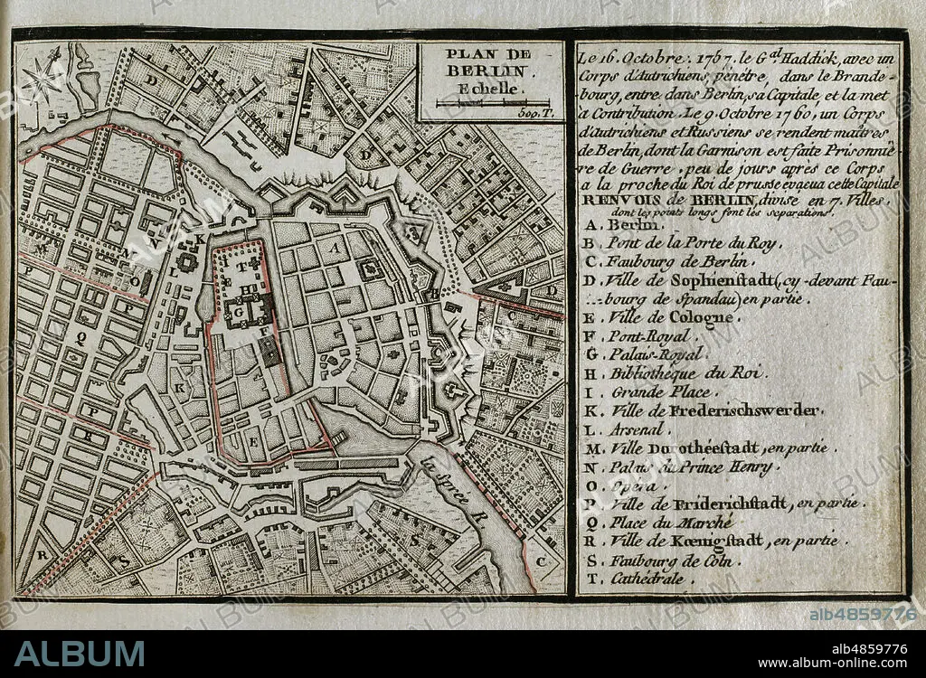
JEAN DE BEAURAIN (1696-1771). FRENCH GEOGRAPHER.. Seven Years War (1756-1763). Third Silesian War. Map of Berlin, 1760. Raid on Berlin. On 9 October 1760, Austrian and Russian troops occupied the Prussian capital of Berlin for a few days. After sacking the city and being informed that the Prussians were sending reinforcements to Berlin, they retreated. Published in 1765 by the cartographer Jean de Beaurain (1696-1771) as an illustration of his Great Map of Germany, with the events that took place during the Seven Years War. Etching and engraving. French edition, 1765. Military Historical Library of Barcelona (Biblioteca Histórico Militar de Barcelona). Catalonia. Spain.
| Share |
|---|
 Pinterest Pinterest |
 Twitter Twitter |
 Facebook Facebook |
 Copy link Copy link |
 Email Email |
|
Add to another lightbox |
|
Add to another lightbox |


Buy this image.
Select the use:

Caption:
Seven Years War (1756-1763). Third Silesian War. Map of Berlin, 1760. Raid on Berlin. On 9 October 1760, Austrian and Russian troops occupied the Prussian capital of Berlin for a few days. After sacking the city and being informed that the Prussians were sending reinforcements to Berlin, they retreated. Published in 1765 by the cartographer Jean de Beaurain (1696-1771) as an illustration of his Great Map of Germany, with the events that took place during the Seven Years War. Etching and engraving. French edition, 1765. Military Historical Library of Barcelona (Biblioteca Histórico Militar de Barcelona). Catalonia. Spain.
Location:
Historical Military Library of Barcelona. Catalonia. Spain.
Credit:
Album / Prisma
Releases:
Image size:
4724 x 3214 px | 43.4 MB
Print size:
40.0 x 27.2 cm | 15.7 x 10.7 in (300 dpi)
Keywords:
1760 • 1765 • 18 CENTURY • 18TH CENTURY • 18TH CENTURY, THE • 18TH CENTURY. • 18TH • ARMY, RUSSIAN • BATTLEFIELD • BEAURAIN • BERLIN • BOOTY • CAPITAL • CARTOGRAPHY • CITY • CONFLICT • CONFLICTS • COUNT VON LACY • COUNT VON TOTTLEBEN • DEUTSCHLAND • ENGRAVED • ENGRAVING (ARTWORK) • ENGRAVING • ENGRAVING. • ENGRAVINGS • ETCHING • EUROPA • EUROPE • EUROPEA • EUROPEAN • EUROPEANS • FRENCH EDITION • GERMAN • GERMANS • GERMANY HISTORY • GERMANY • GOTTLIEB HEINRICH TOTLEBEN • GREAT MAP OF GERMANY • GUERRA • HISTORIA DE ALEMANIA • HISTORIA UNIVERSAL • HISTORIA • HISTORICAL MILITARY LIBRARY OF BARCELONA. CATALONIA. SPAIN. • HISTORY AUSTRIA • HISTORY PRUSSIA • HISTORY RUSSIA • HISTORY • HISTORY, PRUSSIA • HISTORY. • HUNDRED YEARS WAR • INCURSION • INSURRECTION • JEAN DE BEAURAIN (1696-1771). FRENCH GEOGRAPHER. • JEAN DE BEAURAIN • LACY • LOOT • LOOTING • MAP MAKING • MAP • MAPS • MODERN AGE • MODERN ERA • MODERN PERIOD • MUTINY • OCTOBER 9 • OCUPACION • OLD MAP • PILLAGE • PILLAGING • PLAN (CARTOGRAPHY) • PLAN • PLANE • PLUNDERING • PRINT • PRUSIA • PRUSSIA • PRUSSIA, HISTORY • PRUSSIAN CAPITAL • PRUSSIAN EMPIRE • PRUSSIAN • RAID ON BERLIN • RAID • REBELLION • REVOLT • RUSIA • RUSSIA • RUSSIAN ARMY • RUSSIAN TROOPS • RUSSIAN • SACKING • SEVEN YEARS WAR • SEVEN YEARS' WAR • SILESIAN WAR • SILESIAN WARS • THIRD SILESIAN WAR • TOTLEBEN • URBANISM • URBE • VILLAGE • WAR • WAR, SEVEN YEARS • WAR, SILESIAN • WARFARE • WARS • WEIR • XVIII CENTURY
