alb2098908
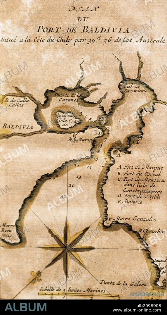
AMERICA DEL SUR. CHILE. SIGLO XVIII. "PLANO DEL PUERTO DE BALDIVIA". VALDIVIA, situada en la costa del Chile y bañada por el rio Valdivia, según un dibujo del año 1713. La Ciudad fue fundada por Jeronimo de Alderate y Pedro de Valdivia en el año 1552. Grabado francés impreso en París en el año 1716.
| Share |
|---|
 Pinterest Pinterest |
 Twitter Twitter |
 Facebook Facebook |
 Copy link Copy link |
 Email Email |
|
Add to another lightbox |
|
Add to another lightbox |


Caption:
Automatic translation: SOUTH AMERICA. CHILE. CENTURY XVIII. "MAP OF THE PORT OF BALDIVIA". VALDIVIA, located on the coast of Chile and bathed by the Valdivia River, according to a drawing from the year 1713. The City was founded by Jeronimo de Alderate and Pedro de Valdivia in the year 1552. French engraving printed in Paris in the year 1716
AMERICA DEL SUR. CHILE. SIGLO XVIII. "PLANO DEL PUERTO DE BALDIVIA". VALDIVIA, situada en la costa del Chile y bañada por el rio Valdivia, según un dibujo del año 1713. La Ciudad fue fundada por Jeronimo de Alderate y Pedro de Valdivia en el año 1552. Grabado francés impreso en París en el año 1716.
Credit:
Album / Prisma
Releases:
Model: No - Property: No
Rights questions?
Rights questions?
Image size:
2717 x 4862 px | 37.8 MB
Print size:
23.0 x 41.2 cm | 9.1 x 16.2 in (300 dpi)
Keywords:
16 16TH XVI XVITH SIXTEENTH CENTURY • 16 CENTURY • 16TH CENTURY • 16TH • 18TH CENTURY • 18TH CENTURY, THE • 18TH • AMERICA • AMERICAS • ANCIENT CARTOGRAPHY • CARTOGRAPHY • CHILE • COMPASS ROSE • COMPASS • ENGRAVED • ENGRAVING (ARTWORK) • ENGRAVING • ENGRAVING. • ENGRAVINGS • ETCHING • HISTORIA UNIVERSAL • HISTORIA • HISTORY ECONOMY • HISTORY • LATIN AMERICA • LATIN AMERICAN • LATINOAMERICA • MAP MAKING • MAP • MAPS • PEDRO DE VALDIVIA • PLAN (CARTOGRAPHY) • PLAN • PLANE • PRINT • SEA TRADE • SOUTH AMERICA • SUDAMERICA • VALDIVIA • WINDROSE
