alb4859079
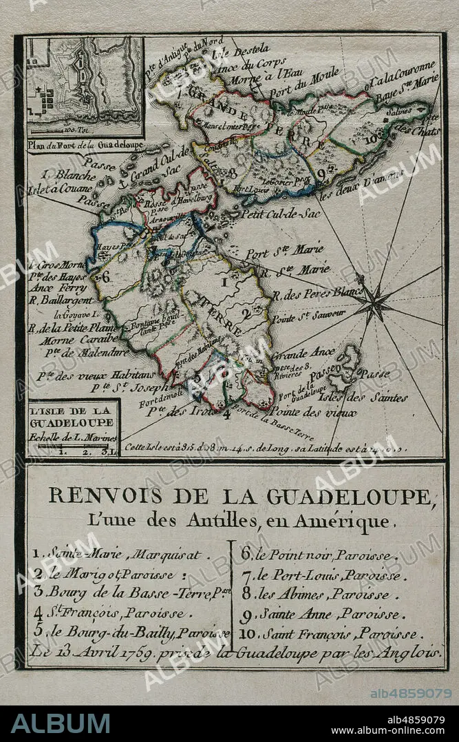
JEAN DE BEAURAIN (1696-1771). FRENCH GEOGRAPHER.. Map of Guadeloupe, 1759. Antilles Archipelago, Caribbean Sea. France took possession of the island on 28 June 1635, after landing at Pointe Allegre. During the Seven Years War, was conquered by England, founding the Port of Pointe-a-Pitre. Taking of the island of Guadeloupe by the British troops on April 13, 1759. Engraving published in 1765 by the cartographer Jean de Beaurain (1696-1771) as an illustration of his Great Map of Germany, with the events that took place during the Seven Years War. French edition, 1765. Military Historical Library of Barcelona (Biblioteca Histórico Militar de Barcelona). Catalonia. Spain.
| Share |
|---|
 Pinterest Pinterest |
 Twitter Twitter |
 Facebook Facebook |
 Copy link Copy link |
 Email Email |
|
Add to another lightbox |
|
Add to another lightbox |


Buy this image.
Select the use:

Caption: Map of Guadeloupe, 1759. Antilles Archipelago, Caribbean Sea. France took possession of the island on 28 June 1635, after landing at Pointe Allegre. During the Seven Years War, was conquered by England, founding the Port of Pointe-a-Pitre. Taking of the island of Guadeloupe by the British troops on April 13, 1759. Engraving published in 1765 by the cartographer Jean de Beaurain (1696-1771) as an illustration of his Great Map of Germany, with the events that took place during the Seven Years War. French edition, 1765. Military Historical Library of Barcelona (Biblioteca Histórico Militar de Barcelona). Catalonia. Spain.
Location: Historical Military Library of Barcelona. Catalonia. Spain.
Credit: Album / Prisma
Releases: ? Model Release: No - ? Property Release: No
Rights questions?
Rights questions?
Image size: 3248 × 4990 px | 46.4 MB
Print size: 27.5 × 42.2 cm | 1278.7 × 1964.6 in (300 dpi)
Keywords: 13 • 1759 • 1765 • 18 CENTURY • 18TH CENTURY • 18TH CENTURY, THE • 18TH CENTURY. • 18TH • AMERICA • AMERICA. • AMERICAS • AMERICAS, THE • ANTILLES ARCHIPELAGO • ANTILLES • ANTILLES, THE • APRIL • ARMY, BRITISH • BEAURAIN • BRITAIN • BRITISH COLONIALISM • BRITISH COLONIES • BRITISH • CARIBBEAN SEA • CARIBBEAN • CARTOGRAPHY • COLONIAL RULE • COLONIAL WARS • COLONIALISM • COMPASS CARD • COMPASS ROSE • COMPASS • CONFISCATION • CONFLICT • CONFLICTS • CONQUERING • CONQUEST • ENGLAND'S • ENGLAND • ENGLAND, HISTORY • ENGLISH ARMY • ENGLISH • ENGRAVED • ENGRAVING (ARTWORK) • ENGRAVING • ENGRAVING. • ENGRAVINGS • ETCHING • FRANCE • FRANCE, HISTORY • FRANCE. • FRANÇAIS • FRENCH COLONIALISM • FRENCH EDITION • FRENCH • GREAT BRITAIN • GREAT MAP OF GERMANY • GREAT-BRITAIN • GUADALUPE • GUADELOUPE • GUERRA • HISTORIA DE FRANCIA • HISTORIA UNIVERSAL • HISTORIA • HISTORICAL MILITARY LIBRARY OF BARCELONA. CATALONIA. SPAIN. • HISTORY ENGLAND • HISTORY FRANCE • HISTORY OF ENGLAND • HISTORY OF FRANCE • HISTORY • HISTORY, ENGLAND • HISTORY, FRANCE • HISTORY. • HUNDRED YEARS WAR • INCURSION • INGLES • INVASION OF GUADELOUPE • INVASION • ISLA • ISLAND OF GUADELOUPE • ISLAND • ISLANDS • JEAN DE BEAURAIN (1696-1771). FRENCH GEOGRAPHER. • JEAN DE BEAURAIN • LA FRANCE • MAP MAKING • MAP • MAPS • MILITARY ACTION • MODERN AGE • MODERN ERA • MODERN PERIOD • OLD MAP • PLAN (CARTOGRAPHY) • PLAN • PLANE • POINTE A PITRE • POINTE-A-PITRE • PORT OF POINTE-A-PITRE • PRINT • QUEEN VICTORIA I • QUEEN VICTORIA • REQUISITION • SEIZURE • SEVEN YEARS WAR • SEVEN YEARS' WAR • SILESIAN WAR • TAKING • THIRTEEN • TRIUMPH • U. K. • UNITED KINGDOM • VICTORIA I • VICTORIA • VICTORY • WAR IN THE COLONIES • WAR • WAR, SEVEN YEARS • WAR, SILESIAN • WARFARE • WARS • WEST INDIES • WIND ROSE • WINDROSE • XVIII CENTURY
