alb5430809
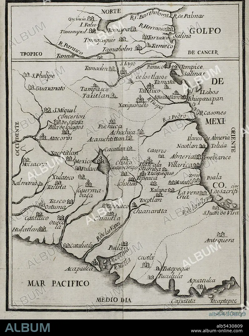
Map of the territory of New Spain. "Historia de la Conquista de México, población, y progresos de la América septentrional, conocida por el nombre de Nueva España" (History of the Conquest of Mexico, population, and progress of northern America, known by the name of New Spain). Written by Antonio de Solís y Rivadeneryra (1610-1686), Chronicler of the Indies. Volume I. Edition published in Barcelona and divided into two volumes, 1771. King's printer: Thomas Piferrer. Historical Military Library of Barcelona. Catalonia, Spain.
| Share |
|---|
 Pinterest Pinterest |
 Twitter Twitter |
 Facebook Facebook |
 Copy link Copy link |
 Email Email |
|
Add to another lightbox |
|
Add to another lightbox |


Buy this image.
Select the use:

Caption: Map of the territory of New Spain. "Historia de la Conquista de México, población, y progresos de la América septentrional, conocida por el nombre de Nueva España" (History of the Conquest of Mexico, population, and progress of northern America, known by the name of New Spain). Written by Antonio de Solís y Rivadeneryra (1610-1686), Chronicler of the Indies. Volume I. Edition published in Barcelona and divided into two volumes, 1771. King's printer: Thomas Piferrer. Historical Military Library of Barcelona. Catalonia, Spain.
Personalities: HERNAN CORTES (1485-1547)
Location: Historical Military Library of Barcelona. Catalonia, Spain.
Credit: Album / Prisma
Releases: ? Model Release: No - ? Property Release: No
Rights questions?
Rights questions?
Image size: 3425 × 4398 px | 43.1 MB
Print size: 29.0 × 37.2 cm | 1348.4 × 1731.5 in (300 dpi)
Keywords: 16 16TH XVI XVITH SIXTEENTH CENTURY • 16 CENTURY • 16TH CENTURY • 16TH • 1771 • 17TH CENTURY • 17TH CENTURY. • 17TH • 17TH-CENTURY • AMERICA NORTH • AMERICA • AMERICA. • AMERICAN CONTINENT • AMERICAS • AMERICAS, THE • ANTONIO DE SOLIS RIVADENEYRA • ANTONIO DE SOLIS Y RIVADENEYRA • AZTEC EMPIRE • AZTEC • AZTECS • CARTOGRAPHY • CHRONICLER • CIUDAD DE MEXICO • CONQUERING • CONQUEST MEXICO • CONQUEST OF MEXICO • CONQUEST • CORTES, HERNAN • FLEET • GEOGRAFIA • GEOGRAPHY • GULF OF MEXICO • HISTORIA DE ESPANA • HISTORIA UNIVERSAL • HISTORIA • HISTORICAL MILITARY LIBRARY OF BARCELONA. CATALONIA, SPAIN. • HISTORY OF MEXICO • HISTORY OF SPAIN • HISTORY OF THE CONQUEST OF MEXICO • HISTORY SPAIN • HISTORY • HISTORY, SPAIN • HISTORY. • INDIAS • INDIES • INDIES, THE • MAP MAKING • MAP • MAPPING • MAPS • MARINE • MESOAMERICA • MESOAMERICAN • MEXICAN • MEXICO CITY • MEXICO • MEXICO, CONQUEST • MODERN AGE • MODERN ERA • MODERN PERIOD • NAVY • NEW SPAIN • NORTH AMERICA • NORTH AMERICAN • NORTHERN AMERICA • NUEVA ESPANA • OCEAN • OCEAN, PACIFIC • OCEANS • PACIFIC OCEAN • PACIFIC • PLAN (CARTOGRAPHY) • QUEEN VICTORIA I • QUEEN VICTORIA • RIVADENEYRA • S. XVII • SEA • SEA. • SEAS • SPAIN, HISTORY • SPANISH CONQUEST OF THE AZTEC EMPIRE • SPANISH EMPIRE • TRIUMPH • TROPIC OF CANCER • TROPIC • VICEROYALTY OF NEW SPAIN • VICEROYALTY • VICTORIA I • VICTORIA • VICTORY • XVI CENTURY • XVII CENTURY
