alb3798235
Great Mississippi River Flood, 1927
| Share |
|---|
 Pinterest Pinterest |
 Twitter Twitter |
 Facebook Facebook |
 Copy link Copy link |
 Email Email |
|
Add to another lightbox |
|
Add to another lightbox |


Buy this image.
Select the use:

Title:
Great Mississippi River Flood, 1927
Caption:
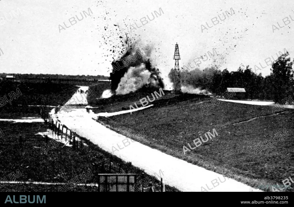
The Great Mississippi Flood of 1927 was the most destructive river flood in the history of the United States. The flood began when heavy rains pounded the central basin of the Mississippi in the summer of 1926. By September, the Mississippi's tributaries in Kansas and Iowa were swollen to capacity. Flooding overtook the levees causing the Mounds Landing to break with more than double the water volume of Niagara Falls. The Mississippi River broke out of its levee system in 145 places and flooded 27,000 square miles. This water flooded an area 50 miles wide and more than 99 miles long. The flood caused over $400 million in damages and killed 246 people in seven states. The flood affected Arkansas, Illinois, Kentucky, Louisiana, Mississippi, Missouri, Tennessee, Texas, Oklahoma and Kansas. By May 1927, the Mississippi River below Memphis, Tennessee, reached a width of 60 miles. Photo originally captioned: "The Great Mississippi River Flood of 1927. Dynamiting through the levee to create an artificial crevasse at Caernarvon, La 14 miles below New Orleans Crevasse created to take pressure off levees at New Orleans."
Credit:
Album / NOAA/Science Source
Releases:
Model: No - Property: No
Rights questions?
Rights questions?
Image size:
1819 x 1186 px | 6.2 MB
Print size:
15.4 x 10.0 cm | 6.1 x 4.0 in (300 dpi)
Keywords:
1920'S • 1920S • 1927 • 20 XX TWENTIETH CENTURY • 20TH CENTURY • 20TH • AFTERMATH • AMERICA • AMERICAN • ATMOSPHERIC CONDITIONS • ATMOSPHERIC • BLOW UP • BW • CATASTROPHE • CATASTROPHIC • CELEBRITIES • CELEBRITY • DAMAGE • DAMAGED • DEADLY • DEBRIS • DESTROYED • DESTRUCTION • DESTRUCTIVE • DEVASTATION • DISASTER • DYNAMITE • EVENT • EVENTS • EXPLODING • EXPLOSION • FAMOUS PEOPLE • FAMOUS • FLOOD DAMAGE • FLOOD • FLOODED • FLOODING • GREAT MISSISSIPPI RIVER FLOOD • HISTORIC • HISTORICAL • HISTORY • HURTING • IMPORTANT • INFLATE • INTENSE • METEOROLOGICAL • METEOROLOGY • METEOROLOGY • MISSISSIPPI RIVER • NATURAL DISASTER • NATURAL PHENOMENA • NATURAL PHENOMENON • NOTABLE • PHENOMENA • PHENOMENON • SCIENCE • SÉVÈRE • STORM DAMAGE • STORM • STRONG WEATHER • TWENTIETH CENTURY • UNITED STATES • US • USA • VIOLENT • WATER DAMAGE • WEATHER EVENT • WEATHER • WELL-KNOWN
