alb3823093
Map of Spanish America, 16th Century
| Share |
|---|
 Pinterest Pinterest |
 Twitter Twitter |
 Facebook Facebook |
 Copy link Copy link |
 Email Email |
|
Add to another lightbox |
|
Add to another lightbox |


Buy this image.
Select the use:

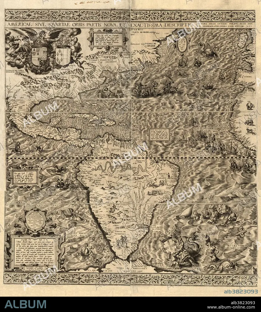
Title: Map of Spanish America, 16th Century
Caption: Spanish America. Map of America produced by the Spanish cartographer Diego Gutierrez in 1562. Only two copies of this map are known to exist, one in the US Library of Congress, and one in the British Library. Numerous illustrations show land and sea animals, ships, South American natives, a Mexican volcano, South American rivers (Amazon and Parana) and mountain ranges. The map shows Spanish domains following a 1559 treaty between Spain and France (their coats of arms are both at top left, Spain at left; Portugal's is at lower right). Next to France's coat of arms is a note that says Americus Vespucius discovered America in 1497. The map was engraved by the Flemish artist Hieronymous Cock.
Category: Historical & Fine Arts
Credit: Album / Science Source / LOC/Geography and Map Division
Releases: ? Model Release: No - ? Property Release: No
Rights questions?
Rights questions?
Image size: 4300 × 4880 px | 60.0 MB
Print size: 36.4 × 41.3 cm | 1692.9 × 1921.3 in (300 dpi)
Keywords: 1500S • 1562 • 16 16TH XVI XVITH SIXTEENTH CENTURY • 16 CENTURY • 16TH CENTURY • 16TH • AMAZON • AMERICA NORTH • AMERICA • AMERICA. • AMERICAN • AMERICAS • AMERICAS, THE • AMERICUS VESPUCIUS • ANCIENT • ANIMAL • ANIMALS • ARTWORK • CARTOGRAPHY • COAT OF ARMS • COATS • CONTINENT • CONTINENTS • CREATURES • DIAGRAM • DIEGO GUTIERREZ • DIPLOMATIC • DOCUMENT • FRANCE • FRENCH • GEOGRAFIA • GEOGRAPHICAL • GEOGRAPHY • HIERONYMOUS COCK • HISTORICAL & FINE ARTS • HISTORICAL • HISTORY • ILLUSTRATED • ILLUSTRATION • ILLUSTRATIONS • ILUSTRATION • INACCURATE • INCOMPLETE • LAND • LATIN • LEGAL • MAP MAKING • MAP • NATIVES • NEW WORLD • NORTH AMERICA • NORTH AMERICAN • OLD • PARANÀ • PORTAIT • PORTRAIT • PORTUGAL • PORTUGUESE • POTRAIT • RARE • RENAISSANCE • RIVER • RIVERS • SEA • SHIPS • SOUTH AMERICA • SPAIN • SPANISH • TREATY • VERTICAL LINES • VERTICAL • VOLCANO • VULCAN • VULCANO • WESTERN HEMISPHERE • XVI CENTURY
