alb9344205
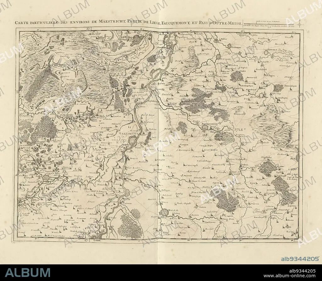
Map of Limburg with the area around Maastricht, 1708, Carte particuliere des environs de Maestricht, partie de Liege, Faucquemont, et Pays d'Outre-Meuse (title on object), Map of Limburg with the area around Maastricht, part of Liege and Valkenburg, 1708. Top right a scale bar: Echelle de deux Lieues de Brabant. The map is provided with a degree division along the edges. Part of a bundled collection of plans of battles and cities renowned in the War of the Spanish Succession. This plate is among the first 24 plates that make up a very large map of the Southern Netherlands., print maker: Jacobus Harrewijn (mentioned on object), publisher: Eugene Henry Fricx (mentioned on object), Brussels, 1708, paper, etching, engraving, height 435 mm × width 560 mm.
| Share |
|---|
 Pinterest Pinterest |
 Twitter Twitter |
 Facebook Facebook |
 Copy link Copy link |
 Email Email |
|
Add to another lightbox |
|
Add to another lightbox |


Buy this image.
Select the use:

Caption:
Map of Limburg with the area around Maastricht, 1708, Carte particuliere des environs de Maestricht, partie de Liege, Faucquemont, et Pays d'Outre-Meuse (title on object), Map of Limburg with the area around Maastricht, part of Liege and Valkenburg, 1708. Top right a scale bar: Echelle de deux Lieues de Brabant. The map is provided with a degree division along the edges. Part of a bundled collection of plans of battles and cities renowned in the War of the Spanish Succession. This plate is among the first 24 plates that make up a very large map of the Southern Netherlands., print maker: Jacobus Harrewijn (mentioned on object), publisher: Eugene Henry Fricx (mentioned on object), Brussels, 1708, paper, etching, engraving, height 435 mm × width 560 mm
Personalities:
Credit:
Album / quintlox
Releases:
Image size:
4926 x 4054 px | 57.1 MB
Print size:
41.7 x 34.3 cm | 16.4 x 13.5 in (300 dpi)
Keywords:
1708 • AREA • BATTLES • BRUSSELS • BUNDLED COLLECTION • CARTE PARTICULIERE DES ENVIRONS DE MAESTRICHT • CITIES RENOWNED • CITY OF BRUSSELS • DEGREE DIVISION • DISH • ECHELLE DE DEUX LIEUES DE BRABANT • EDGES • ENGRAVED • ENGRAVING (ARTWORK) • ENGRAVING • ENGRAVING. • ENGRAVINGS • ET PAYS D'OUTRE-MEUSE • ETCHING • EUGENE HENRY FRICX • FAUCQUEMONT • FIRST 24 PLATES • GUERRA • HEIGHT 435 MM • HUNDRED YEARS WAR • JACOBUS HARREWIJN • LARGE MAP • LIÈGE • LIMBURG • MAASTRICHT • MAP • MAPS • MENTIONED • PAPER AND PACKAGE PRODUCTS • PAPER • PART • PARTIE DE LIEGE • PLAN (CARTOGRAPHY) • PLANS • PLATE • PRINT MAKER • PRINT • PROVIDED • PUBLISHER • SCALE BAR • SOUTHERN NETHERLANDS • SPANISH SUCCESSION • TOP RIGHT • UP A • VALKENBURG • WAR • WARFARE • WARS • WIDTH 560 MM
