alb4618432
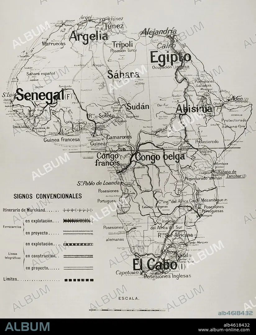
European Imperialism. Sketch of the African continent showing the boundaries agreed at the time between the various European powers, and the railways and telegraphs in operation, under construction and in the pipeline. La Ilustración Española y Americana, 1898.
| Share |
|---|
 Pinterest Pinterest |
 Twitter Twitter |
 Facebook Facebook |
 Copy link Copy link |
 Email Email |
|
Add to another lightbox |
|
Add to another lightbox |


Buy this image.
Select the use:

Caption: European Imperialism. Sketch of the African continent showing the boundaries agreed at the time between the various European powers, and the railways and telegraphs in operation, under construction and in the pipeline. La Ilustración Española y Americana, 1898.
Location: PRIVATE COLLECTION
Credit: Album / Prisma
Releases: ? Model Release: No - ? Property Release: No
Rights questions?
Rights questions?
Image size: 3130 × 3892 px | 34.9 MB
Print size: 26.5 × 33.0 cm | 1232.3 × 1532.3 in (300 dpi)
Keywords: 1898 • 19 CENTURY • 19TH CENTURY • 19TH CENTURY. • 19TH • 19TH-CENTURY • ABYSSINIA • AFRICA • AFRICAN CONTINENT • AFRICAN • ALGERIA • ALGIERS • BELGIAN COLONIALISM • BELGIAN CONGO • BORDER • BORDERS • BRITISH COLONIALISM • BUILDING • CARTOGRAPHY • CHECKING • CLAY MODEL • COLONIALISM • COLONIES • COMMUNICATIONS • CONGO • CONQUEST OF AFRICA • CONSTRUCTION • CONSTRUCTIONS • CONTEMPORARY AGE • CONTEMPORARY PERIOD • CONTROL • COSTUME SKETCH • DESIGN • DISTRIBUTION • DIVISION • DRAFT • EGYPT • EGYPTE • EGYPTIAN • EGYPTIANS • ENGLISH COLONIALISM • ENGRAVED • ENGRAVING (ARTWORK) • ENGRAVING • ENGRAVING. • ENGRAVINGS • ETCHING • EUROPEAN COUNTRIES • EUROPEAN IMPERIALISM • EUROPEAN POWERS • EXPLOITATION • FRENCH COLONIALISM • FRENCH CONGO • FRONTIER • GERMAN COLONIALISM • HISTORIA UNIVERSAL • HISTORIA • HISTORY • HISTORY. • IMPERIALISM • INSPECTION • ITALIAN COLONIALISM • LA ILUSTRACION ESPANOLA Y AMERICANA • LATE NINETEENTH CENTURY • LEGEND (STORY) • LEGEND • LIMITS • MAP KEY • MAP LEGEND • MAP MAKING • MAP • MAPPING • MAPS • MYTH • NATIONS • NEW IMPERIALISM • NINETEENTH CENTURY • PARTITION OF AFRICA • PLAN (CARTOGRAPHY) • PRINT • PRIVATE COLLECTION • PROJECT • PROTOTYPE • RAIL NETWORK • RAIL • RAILROAD • RAILS • RAILWAY NETWORK • RAILWAY • RAILWAYS • SAHARA • SCRAMBLE FOR AFRICA • SENEGAL • SEPARATION • SKETCH • SPANISH AND AMERICAN ILLUSTRATION, THE • SUDAN • SUPERVISION • TELEGRAPH COMMUNICATIONS • TELEGRAPH • TELEGRAPHS • TELEGRAPHY = TELEGRAPH COMMUNICATIONS • TELEGRAPHY • TERRITORIAL DIVISION • TERRITORIAL • TERRITORY • TRAIN • TRAINS • TRAIT • XIX CENTURY • ZAIRE
